You are here: Home > Network List > TA - USArray Transportable Network (new EarthScope stations) Stations List
> Station E23K Chandalar, AK, USA > Earthquake Result Viewer
E23K Chandalar, AK, USA - Earthquake Result Viewer
| Earthquake location: |
Northern Molucca Sea |
| Earthquake latitude/longitude: |
2.2/126.7 |
| Earthquake time(UTC): |
2019/01/06 (006) 17:27:20 GMT |
| Earthquake Depth: |
61 km |
| Earthquake Magnitude: |
6.6 mww |
| Earthquake Catalog/Contributor: |
NEIC PDE/us |
|
| Network: |
TA USArray Transportable Network (new EarthScope stations) |
| Station: |
E23K Chandalar, AK, USA |
| Lat/Lon: |
68.06 N/149.62 W |
| Elevation: |
1084 m |
|
| Distance: |
85.6 deg |
| Az: |
22.002 deg |
| Baz: |
264.933 deg |
| Ray Param: |
0.044564813 |
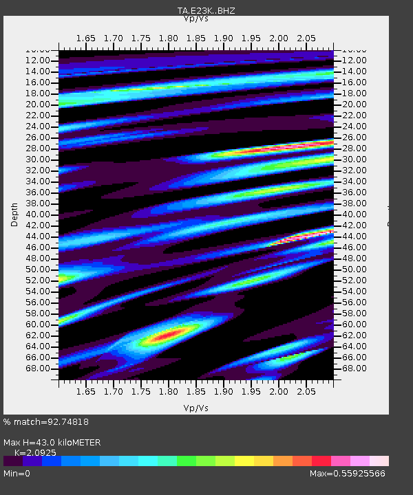
| Estimated Moho Depth: |
43.0 km |
| Estimated Crust Vp/Vs: |
2.09 |
| Assumed Crust Vp: |
6.316 km/s |
| Estimated Crust Vs: |
3.019 km/s |
| Estimated Crust Poisson's Ratio: |
0.35 |
|
| Radial Match: |
92.74818 % |
| Radial Bump: |
400 |
| Transverse Match: |
89.705574 % |
| Transverse Bump: |
400 |
| SOD ConfigId: |
13570011 |
| Insert Time: |
2019-05-02 06:44:45.054 +0000 |
| GWidth: |
2.5 |
| Max Bumps: |
400 |
| Tol: |
0.001 |
|

Signal To Noise
| Channel | StoN | STA | LTA |
| TA:E23K: :BHZ:20190106T17:39:21.174995Z | 6.7616515 | 1.8799046E-6 | 2.780245E-7 |
| TA:E23K: :BHN:20190106T17:39:21.174995Z | 1.05429 | 2.093926E-7 | 1.9861004E-7 |
| TA:E23K: :BHE:20190106T17:39:21.174995Z | 2.1747482 | 4.3967006E-7 | 2.0217055E-7 |
| Arrivals |
| Ps | 7.6 SECOND |
| PpPs | 21 SECOND |
| PsPs/PpSs | 28 SECOND |


