You are here: Home > Network List > TA - USArray Transportable Network (new EarthScope stations) Stations List
> Station E27K Coleen River, AK, USA > Earthquake Result Viewer
E27K Coleen River, AK, USA - Earthquake Result Viewer
| Earthquake location: |
Northern Molucca Sea |
| Earthquake latitude/longitude: |
2.2/126.7 |
| Earthquake time(UTC): |
2019/01/06 (006) 17:27:20 GMT |
| Earthquake Depth: |
61 km |
| Earthquake Magnitude: |
6.6 mww |
| Earthquake Catalog/Contributor: |
NEIC PDE/us |
|
| Network: |
TA USArray Transportable Network (new EarthScope stations) |
| Station: |
E27K Coleen River, AK, USA |
| Lat/Lon: |
68.19 N/141.60 W |
| Elevation: |
654 m |
|
| Distance: |
88.6 deg |
| Az: |
21.944 deg |
| Baz: |
272.369 deg |
| Ray Param: |
0.042380743 |
| Estimated Moho Depth: |
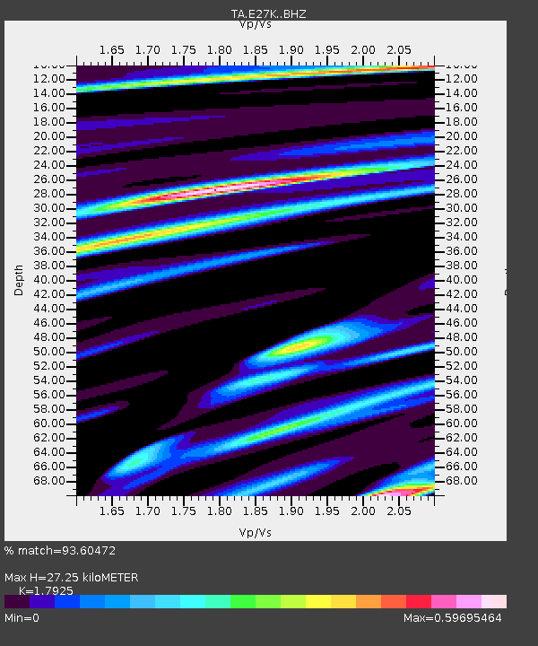
27.25 km |
| Estimated Crust Vp/Vs: |
1.79 |
| Assumed Crust Vp: |
6.522 km/s |
| Estimated Crust Vs: |
3.638 km/s |
| Estimated Crust Poisson's Ratio: |
0.27 |
|
| Radial Match: |
93.60472 % |
| Radial Bump: |
400 |
| Transverse Match: |
84.55728 % |
| Transverse Bump: |
400 |
| SOD ConfigId: |
13570011 |
| Insert Time: |
2019-05-02 06:44:48.355 +0000 |
| GWidth: |
2.5 |
| Max Bumps: |
400 |
| Tol: |
0.001 |
|

Signal To Noise
| Channel | StoN | STA | LTA |
| TA:E27K: :BHZ:20190106T17:39:35.70002Z | 15.194572 | 1.3939106E-6 | 9.17374E-8 |
| TA:E27K: :BHN:20190106T17:39:35.70002Z | 2.894085 | 2.625699E-7 | 9.0726395E-8 |
| TA:E27K: :BHE:20190106T17:39:35.70002Z | 3.4649208 | 3.9904438E-7 | 1.1516696E-7 |
| Arrivals |
| Ps | 3.4 SECOND |
| PpPs | 11 SECOND |
| PsPs/PpSs | 15 SECOND |


