You are here: Home > Network List > TA - USArray Transportable Network (new EarthScope stations) Stations List
> Station E28M Babbage River, YT, CAN > Earthquake Result Viewer
E28M Babbage River, YT, CAN - Earthquake Result Viewer
| Earthquake location: |
Northern Molucca Sea |
| Earthquake latitude/longitude: |
2.2/126.7 |
| Earthquake time(UTC): |
2019/01/06 (006) 17:27:20 GMT |
| Earthquake Depth: |
61 km |
| Earthquake Magnitude: |
6.6 mww |
| Earthquake Catalog/Contributor: |
NEIC PDE/us |
|
| Network: |
TA USArray Transportable Network (new EarthScope stations) |
| Station: |
E28M Babbage River, YT, CAN |
| Lat/Lon: |
68.60 N/139.53 W |
| Elevation: |
474 m |
|
| Distance: |
89.3 deg |
| Az: |
21.481 deg |
| Baz: |
274.274 deg |
| Ray Param: |
0.04184181 |
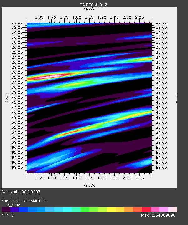
| Estimated Moho Depth: |
31.5 km |
| Estimated Crust Vp/Vs: |
1.69 |
| Assumed Crust Vp: |
6.316 km/s |
| Estimated Crust Vs: |
3.737 km/s |
| Estimated Crust Poisson's Ratio: |
0.23 |
|
| Radial Match: |
88.13237 % |
| Radial Bump: |
400 |
| Transverse Match: |
73.427795 % |
| Transverse Bump: |
400 |
| SOD ConfigId: |
13570011 |
| Insert Time: |
2019-05-02 06:44:48.952 +0000 |
| GWidth: |
2.5 |
| Max Bumps: |
400 |
| Tol: |
0.001 |
|

Signal To Noise
| Channel | StoN | STA | LTA |
| TA:E28M: :BHZ:20190106T17:39:39.149971Z | 5.0898294 | 1.249121E-6 | 2.454151E-7 |
| TA:E28M: :BHN:20190106T17:39:39.149971Z | 1.6099659 | 2.2352803E-7 | 1.3884022E-7 |
| TA:E28M: :BHE:20190106T17:39:39.149971Z | 3.1235473 | 3.7535455E-7 | 1.201693E-7 |
| Arrivals |
| Ps | 3.5 SECOND |
| PpPs | 13 SECOND |
| PsPs/PpSs | 17 SECOND |


