You are here: Home > Network List > TA - USArray Transportable Network (new EarthScope stations) Stations List
> Station J19A Crowheart, WY, USA > Earthquake Result Viewer
J19A Crowheart, WY, USA - Earthquake Result Viewer
| Earthquake location: |
Hokkaido, Japan Region |
| Earthquake latitude/longitude: |
41.9/143.8 |
| Earthquake time(UTC): |
2008/09/11 (255) 00:20:50 GMT |
| Earthquake Depth: |
25 km |
| Earthquake Magnitude: |
6.1 MB, 7.0 MS, 6.8 MW, 6.8 MW |
| Earthquake Catalog/Contributor: |
WHDF/NEIC |
|
| Network: |
TA USArray Transportable Network (new EarthScope stations) |
| Station: |
J19A Crowheart, WY, USA |
| Lat/Lon: |
43.26 N/109.05 W |
| Elevation: |
1782 m |
|
| Distance: |
73.0 deg |
| Az: |
46.878 deg |
| Baz: |
311.752 deg |
| Ray Param: |
0.05328995 |
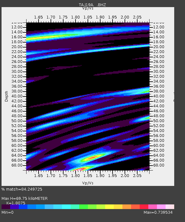
| Estimated Moho Depth: |
69.75 km |
| Estimated Crust Vp/Vs: |
1.81 |
| Assumed Crust Vp: |
6.161 km/s |
| Estimated Crust Vs: |
3.409 km/s |
| Estimated Crust Poisson's Ratio: |
0.28 |
|
| Radial Match: |
84.249725 % |
| Radial Bump: |
368 |
| Transverse Match: |
83.45889 % |
| Transverse Bump: |
400 |
| SOD ConfigId: |
2560 |
| Insert Time: |
2010-03-06 19:18:20.693 +0000 |
| GWidth: |
2.5 |
| Max Bumps: |
400 |
| Tol: |
0.001 |
|
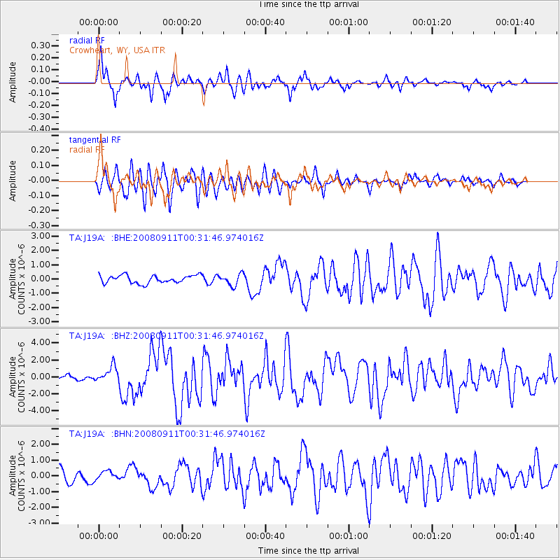
Signal To Noise
| Channel | StoN | STA | LTA |
| TA:J19A: :BHZ:20080911T00:31:46.974016Z | 3.2096696 | 9.839781E-7 | 3.065668E-7 |
| TA:J19A: :BHN:20080911T00:31:46.974016Z | 0.7507564 | 2.8254058E-7 | 3.7634123E-7 |
| TA:J19A: :BHE:20080911T00:31:46.974016Z | 1.4923592 | 4.1416564E-7 | 2.7752412E-7 |
| Arrivals |
| Ps | 9.4 SECOND |
| PpPs | 31 SECOND |
| PsPs/PpSs | 40 SECOND |


