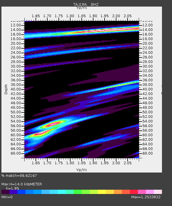
J19A Crowheart, WY, USA - Earthquake Result Viewer
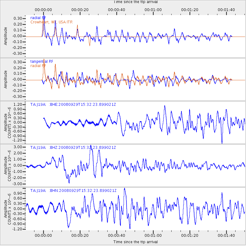
Earthquake location: Kermadec Islands, New Zealand
Earthquake latitude/longitude: -29.8/-177.7
Earthquake time(UTC): 2008/09/29 (273) 15:19:31 GMT
Earthquake Depth: 36 km
Earthquake Magnitude: 6.5 MB, 6.7 MS, 7.0 MW, 7.0 MW
Earthquake Catalog/Contributor: WHDF/NEIC
Network: TA USArray Transportable Network (new EarthScope stations)
Station: J19A Crowheart, WY, USA
Lat/Lon: 43.26 N/109.05 W
Elevation: 1782 m
Distance: 96.1 deg
Az: 43.165 deg
Baz: 234.524 deg
Ray Param: 0.04059768
Estimated Moho Depth: 14.0 km
Estimated Crust Vp/Vs: 1.95
Assumed Crust Vp: 6.161 km/s
Estimated Crust Vs: 3.159 km/s
Estimated Crust Poisson's Ratio: 0.32
Radial Match: 86.62167 %
Radial Bump: 400
Transverse Match: 74.75672 %
Transverse Bump: 400
SOD ConfigId: 2560
Insert Time: 2010-03-06 19:18:22.545 +0000
GWidth: 2.5
Max Bumps: 400
Tol: 0.001

Signal To Noise

ChannelStoNSTALTA
TA:J19A: :BHZ:20080929T15:32:23.899021Z5.56915765.0403514E-79.0504734E-8
TA:J19A: :BHN:20080929T15:32:23.899021Z1.49471682.2333816E-71.494184E-7
TA:J19A: :BHE:20080929T15:32:23.899021Z1.16930681.4890163E-71.273418E-7
Arrivals
Ps2.2 SECOND
PpPs6.6 SECOND
PsPs/PpSs8.8 SECOND