You are here: Home > Network List > TA - USArray Transportable Network (new EarthScope stations) Stations List
> Station J19A Crowheart, WY, USA > Earthquake Result Viewer
J19A Crowheart, WY, USA - Earthquake Result Viewer
| Earthquake location: |
Samoa Islands Region |
| Earthquake latitude/longitude: |
-15.2/-172.6 |
| Earthquake time(UTC): |
2009/08/30 (242) 14:51:32 GMT |
| Earthquake Depth: |
11 km |
| Earthquake Magnitude: |
6.4 MB, 6.3 MS, 6.6 MW, 6.6 MW |
| Earthquake Catalog/Contributor: |
WHDF/NEIC |
|
| Network: |
TA USArray Transportable Network (new EarthScope stations) |
| Station: |
J19A Crowheart, WY, USA |
| Lat/Lon: |
43.26 N/109.05 W |
| Elevation: |
1782 m |
|
| Distance: |
82.2 deg |
| Az: |
41.299 deg |
| Baz: |
240.715 deg |
| Ray Param: |
0.04707186 |
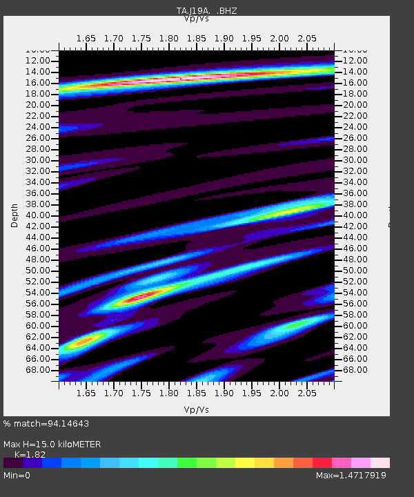
| Estimated Moho Depth: |
15.0 km |
| Estimated Crust Vp/Vs: |
1.82 |
| Assumed Crust Vp: |
6.161 km/s |
| Estimated Crust Vs: |
3.385 km/s |
| Estimated Crust Poisson's Ratio: |
0.28 |
|
| Radial Match: |
94.14643 % |
| Radial Bump: |
374 |
| Transverse Match: |
85.860374 % |
| Transverse Bump: |
400 |
| SOD ConfigId: |
2622 |
| Insert Time: |
2010-03-06 19:18:30.028 +0000 |
| GWidth: |
2.5 |
| Max Bumps: |
400 |
| Tol: |
0.001 |
|
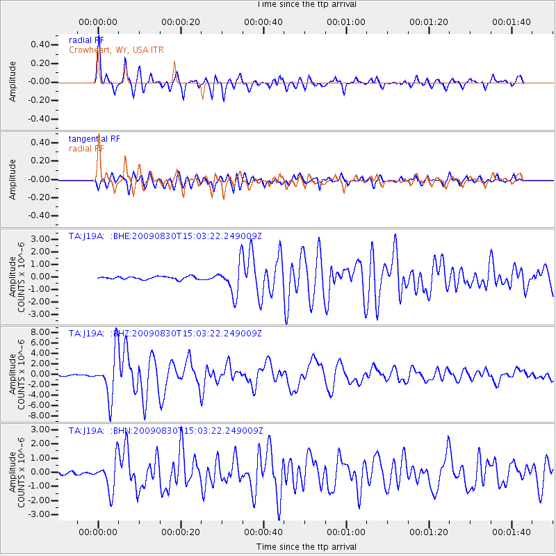
Signal To Noise
| Channel | StoN | STA | LTA |
| TA:J19A: :BHZ:20090830T15:03:22.249009Z | 31.798561 | 4.524277E-6 | 1.4227929E-7 |
| TA:J19A: :BHN:20090830T15:03:22.249009Z | 17.46141 | 1.1645546E-6 | 6.669304E-8 |
| TA:J19A: :BHE:20090830T15:03:22.249009Z | 11.336385 | 1.3019766E-6 | 1.14849364E-7 |
| Arrivals |
| Ps | 2.0 SECOND |
| PpPs | 6.7 SECOND |
| PsPs/PpSs | 8.7 SECOND |


