You are here: Home > Network List > TA - USArray Transportable Network (new EarthScope stations) Stations List
> Station H31M Peel River, Yukon, CAN > Earthquake Result Viewer
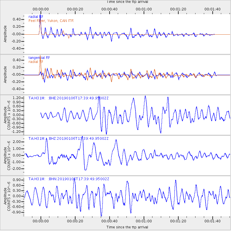
H31M Peel River, Yukon, CAN - Earthquake Result Viewer
*The percent match for this event was below the threshold and hence no stack was calculated.
| Earthquake location: |
Northern Molucca Sea |
| Earthquake latitude/longitude: |
2.2/126.7 |
| Earthquake time(UTC): |
2019/01/06 (006) 17:27:20 GMT |
| Earthquake Depth: |
61 km |
| Earthquake Magnitude: |
6.6 mww |
| Earthquake Catalog/Contributor: |
NEIC PDE/us |
|
| Network: |
TA USArray Transportable Network (new EarthScope stations) |
| Station: |
H31M Peel River, Yukon, CAN |
| Lat/Lon: |
65.81 N/134.34 W |
| Elevation: |
642 m |
|
| Distance: |
91.6 deg |
| Az: |
24.037 deg |
| Baz: |
279.036 deg |
| Ray Param: |
$rayparam |
*The percent match for this event was below the threshold and hence was not used in the summary stack. |
|
| Radial Match: |
75.8363 % |
| Radial Bump: |
400 |
| Transverse Match: |
63.376934 % |
| Transverse Bump: |
400 |
| SOD ConfigId: |
13570011 |
| Insert Time: |
2019-05-02 06:45:19.784 +0000 |
| GWidth: |
2.5 |
| Max Bumps: |
400 |
| Tol: |
0.001 |
|
Signal To Noise
| Channel | StoN | STA | LTA |
| TA:H31M: :BHZ:20190106T17:39:49.95002Z | 7.2443666 | 1.0852281E-6 | 1.4980303E-7 |
| TA:H31M: :BHN:20190106T17:39:49.95002Z | 1.8375261 | 3.9641802E-7 | 2.1573463E-7 |
| TA:H31M: :BHE:20190106T17:39:49.95002Z | 2.6671665 | 5.7020657E-7 | 2.137874E-7 |
| Arrivals |
| Ps | |
| PpPs | |
| PsPs/PpSs | |


