You are here: Home > Network List > TA - USArray Transportable Network (new EarthScope stations) Stations List
> Station J19A Crowheart, WY, USA > Earthquake Result Viewer
J19A Crowheart, WY, USA - Earthquake Result Viewer
| Earthquake location: |
Samoa Islands Region |
| Earthquake latitude/longitude: |
-15.4/-172.3 |
| Earthquake time(UTC): |
2009/10/19 (292) 22:49:38 GMT |
| Earthquake Depth: |
18 km |
| Earthquake Magnitude: |
6.2 MB, 5.7 MS, 6.0 MW, 5.9 MW |
| Earthquake Catalog/Contributor: |
WHDF/NEIC |
|
| Network: |
TA USArray Transportable Network (new EarthScope stations) |
| Station: |
J19A Crowheart, WY, USA |
| Lat/Lon: |
43.26 N/109.05 W |
| Elevation: |
1782 m |
|
| Distance: |
82.1 deg |
| Az: |
41.176 deg |
| Baz: |
240.4 deg |
| Ray Param: |
0.047123764 |
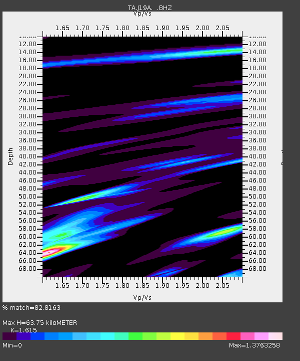
| Estimated Moho Depth: |
63.75 km |
| Estimated Crust Vp/Vs: |
1.62 |
| Assumed Crust Vp: |
6.161 km/s |
| Estimated Crust Vs: |
3.815 km/s |
| Estimated Crust Poisson's Ratio: |
0.19 |
|
| Radial Match: |
82.8163 % |
| Radial Bump: |
400 |
| Transverse Match: |
76.577446 % |
| Transverse Bump: |
400 |
| SOD ConfigId: |
2622 |
| Insert Time: |
2010-03-06 19:18:36.289 +0000 |
| GWidth: |
2.5 |
| Max Bumps: |
400 |
| Tol: |
0.001 |
|
Signal To Noise
| Channel | StoN | STA | LTA |
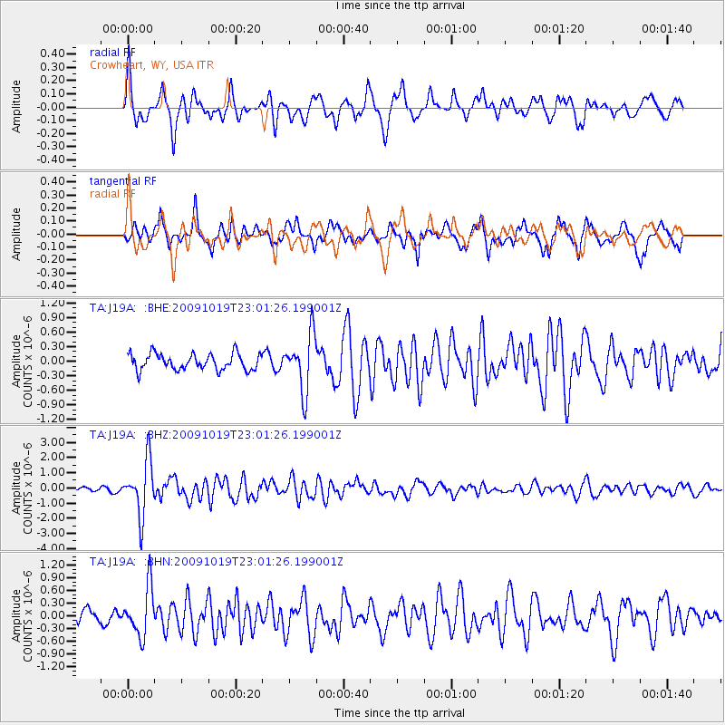
| TA:J19A: :BHZ:20091019T23:01:26.199001Z | 10.528902 | 1.7971865E-6 | 1.7069078E-7 |
| TA:J19A: :BHN:20091019T23:01:26.199001Z | 3.3627799 | 5.8542594E-7 | 1.7408988E-7 |
| TA:J19A: :BHE:20091019T23:01:26.199001Z | 3.5896356 | 5.921258E-7 | 1.6495429E-7 |
| Arrivals |
| Ps | 6.5 SECOND |
| PpPs | 26 SECOND |
| PsPs/PpSs | 33 SECOND |


