You are here: Home > Network List > TA - USArray Transportable Network (new EarthScope stations) Stations List
> Station K15K Wolf Creek Mountain, AK, USA > Earthquake Result Viewer
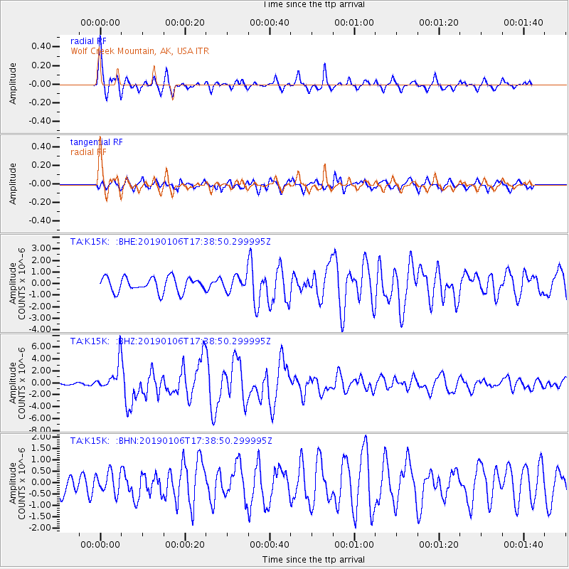
K15K Wolf Creek Mountain, AK, USA - Earthquake Result Viewer
| Earthquake location: |
Northern Molucca Sea |
| Earthquake latitude/longitude: |
2.2/126.7 |
| Earthquake time(UTC): |
2019/01/06 (006) 17:27:20 GMT |
| Earthquake Depth: |
61 km |
| Earthquake Magnitude: |
6.6 mww |
| Earthquake Catalog/Contributor: |
NEIC PDE/us |
|
| Network: |
TA USArray Transportable Network (new EarthScope stations) |
| Station: |
K15K Wolf Creek Mountain, AK, USA |
| Lat/Lon: |
62.29 N/161.53 W |
| Elevation: |
346 m |
|
| Distance: |
79.6 deg |
| Az: |
26.823 deg |
| Baz: |
254.736 deg |
| Ray Param: |
0.048735183 |
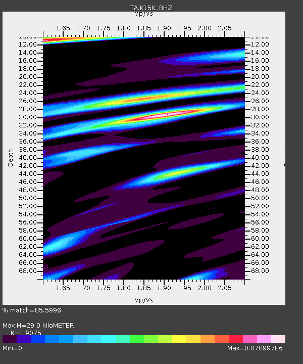
| Estimated Moho Depth: |
29.0 km |
| Estimated Crust Vp/Vs: |
1.91 |
| Assumed Crust Vp: |
6.276 km/s |
| Estimated Crust Vs: |
3.29 km/s |
| Estimated Crust Poisson's Ratio: |
0.31 |
|
| Radial Match: |
85.5996 % |
| Radial Bump: |
361 |
| Transverse Match: |
71.53124 % |
| Transverse Bump: |
400 |
| SOD ConfigId: |
13570011 |
| Insert Time: |
2019-05-02 06:45:33.803 +0000 |
| GWidth: |
2.5 |
| Max Bumps: |
400 |
| Tol: |
0.001 |
|
Signal To Noise
| Channel | StoN | STA | LTA |
| TA:K15K: :BHZ:20190106T17:38:50.299995Z | 6.0534754 | 2.4776205E-6 | 4.0928896E-7 |
| TA:K15K: :BHN:20190106T17:38:50.299995Z | 0.8260601 | 4.7026285E-7 | 5.6928405E-7 |
| TA:K15K: :BHE:20190106T17:38:50.299995Z | 1.2942035 | 8.145822E-7 | 6.2940813E-7 |
| Arrivals |
| Ps | 4.3 SECOND |
| PpPs | 13 SECOND |
| PsPs/PpSs | 17 SECOND |


