You are here: Home > Network List > TA - USArray Transportable Network (new EarthScope stations) Stations List
> Station J19A Crowheart, WY, USA > Earthquake Result Viewer
J19A Crowheart, WY, USA - Earthquake Result Viewer
| Earthquake location: |
Kermadec Islands Region |
| Earthquake latitude/longitude: |
-27.4/-176.3 |
| Earthquake time(UTC): |
2009/02/18 (049) 21:53:45 GMT |
| Earthquake Depth: |
25 km |
| Earthquake Magnitude: |
6.8 MB, 7.2 MS, 6.9 MW, 6.9 MW |
| Earthquake Catalog/Contributor: |
WHDF/NEIC |
|
| Network: |
TA USArray Transportable Network (new EarthScope stations) |
| Station: |
J19A Crowheart, WY, USA |
| Lat/Lon: |
43.26 N/109.05 W |
| Elevation: |
1782 m |
|
| Distance: |
93.6 deg |
| Az: |
42.461 deg |
| Baz: |
235.232 deg |
| Ray Param: |
0.041230105 |
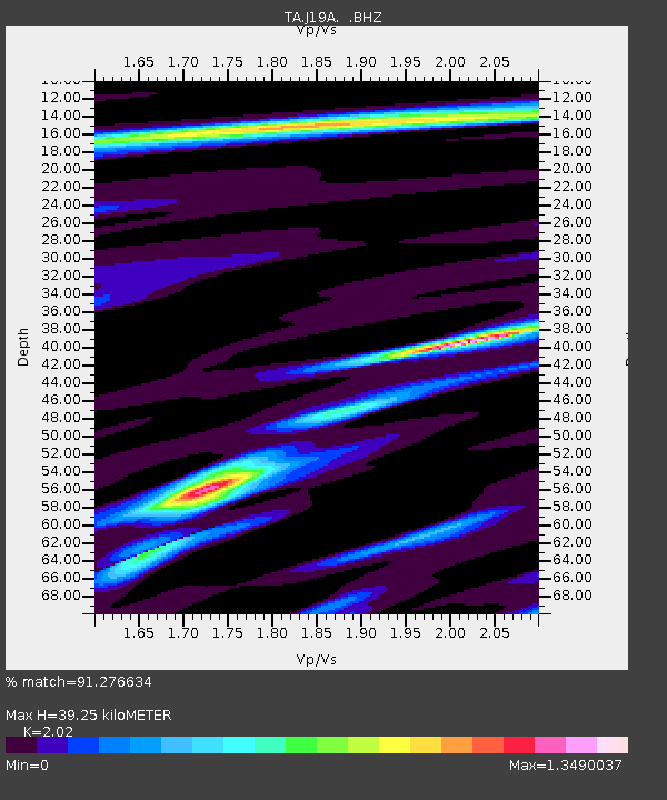
| Estimated Moho Depth: |
39.25 km |
| Estimated Crust Vp/Vs: |
2.02 |
| Assumed Crust Vp: |
6.161 km/s |
| Estimated Crust Vs: |
3.05 km/s |
| Estimated Crust Poisson's Ratio: |
0.34 |
|
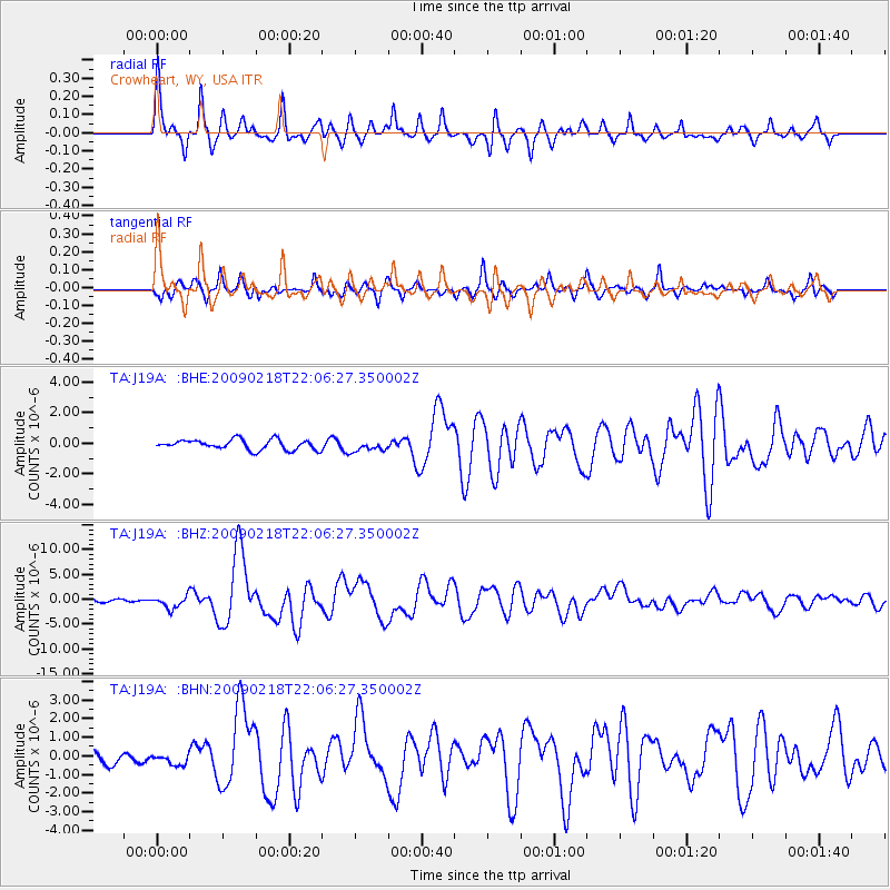
| Radial Match: |
91.276634 % |
| Radial Bump: |
289 |
| Transverse Match: |
76.675026 % |
| Transverse Bump: |
375 |
| SOD ConfigId: |
2658 |
| Insert Time: |
2010-03-06 19:18:39.205 +0000 |
| GWidth: |
2.5 |
| Max Bumps: |
400 |
| Tol: |
0.001 |
|
Signal To Noise
| Channel | StoN | STA | LTA |
| TA:J19A: :BHZ:20090218T22:06:27.350002Z | 3.6286361 | 1.2735231E-6 | 3.5096468E-7 |
| TA:J19A: :BHN:20090218T22:06:27.350002Z | 0.60898185 | 3.0299995E-7 | 4.975517E-7 |
| TA:J19A: :BHE:20090218T22:06:27.350002Z | 1.0616313 | 3.4622772E-7 | 3.26128E-7 |
| Arrivals |
| Ps | 6.6 SECOND |
| PpPs | 19 SECOND |
| PsPs/PpSs | 26 SECOND |


