You are here: Home > Network List > TA - USArray Transportable Network (new EarthScope stations) Stations List
> Station J19A Crowheart, WY, USA > Earthquake Result Viewer
J19A Crowheart, WY, USA - Earthquake Result Viewer
| Earthquake location: |
Hokkaido, Japan Region |
| Earthquake latitude/longitude: |
41.8/143.4 |
| Earthquake time(UTC): |
2009/06/05 (156) 03:30:33 GMT |
| Earthquake Depth: |
29 km |
| Earthquake Magnitude: |
6.0 MB, 6.3 MS, 6.4 MW, 6.4 MW |
| Earthquake Catalog/Contributor: |
WHDF/NEIC |
|
| Network: |
TA USArray Transportable Network (new EarthScope stations) |
| Station: |
J19A Crowheart, WY, USA |
| Lat/Lon: |
43.26 N/109.05 W |
| Elevation: |
1782 m |
|
| Distance: |
73.2 deg |
| Az: |
46.706 deg |
| Baz: |
311.866 deg |
| Ray Param: |
0.053140562 |
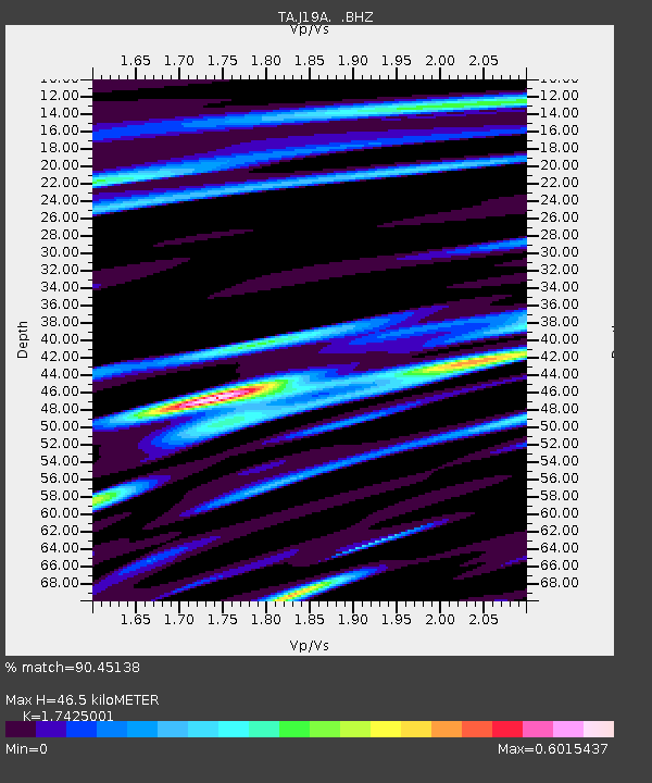
| Estimated Moho Depth: |
46.5 km |
| Estimated Crust Vp/Vs: |
1.74 |
| Assumed Crust Vp: |
6.161 km/s |
| Estimated Crust Vs: |
3.536 km/s |
| Estimated Crust Poisson's Ratio: |
0.25 |
|
| Radial Match: |
90.45138 % |
| Radial Bump: |
400 |
| Transverse Match: |
88.486984 % |
| Transverse Bump: |
400 |
| SOD ConfigId: |
2648 |
| Insert Time: |
2010-03-06 19:18:45.596 +0000 |
| GWidth: |
2.5 |
| Max Bumps: |
400 |
| Tol: |
0.001 |
|
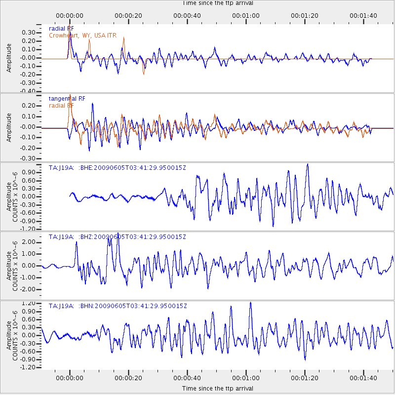
Signal To Noise
| Channel | StoN | STA | LTA |
| TA:J19A: :BHZ:20090605T03:41:29.950015Z | 9.919502 | 7.0666005E-7 | 7.123947E-8 |
| TA:J19A: :BHN:20090605T03:41:29.950015Z | 0.7262912 | 8.065989E-8 | 1.1105723E-7 |
| TA:J19A: :BHE:20090605T03:41:29.950015Z | 2.1555564 | 1.667566E-7 | 7.7361285E-8 |
| Arrivals |
| Ps | 5.8 SECOND |
| PpPs | 20 SECOND |
| PsPs/PpSs | 26 SECOND |


