You are here: Home > Network List > TA - USArray Transportable Network (new EarthScope stations) Stations List
> Station O17K Koliganek, Bristol Bay, AK, USA > Earthquake Result Viewer
O17K Koliganek, Bristol Bay, AK, USA - Earthquake Result Viewer
| Earthquake location: |
Northern Molucca Sea |
| Earthquake latitude/longitude: |
2.2/126.7 |
| Earthquake time(UTC): |
2019/01/06 (006) 17:27:20 GMT |
| Earthquake Depth: |
61 km |
| Earthquake Magnitude: |
6.6 mww |
| Earthquake Catalog/Contributor: |
NEIC PDE/us |
|
| Network: |
TA USArray Transportable Network (new EarthScope stations) |
| Station: |
O17K Koliganek, Bristol Bay, AK, USA |
| Lat/Lon: |
59.77 N/157.09 W |
| Elevation: |
156 m |
|
| Distance: |
81.1 deg |
| Az: |
29.816 deg |
| Baz: |
259.113 deg |
| Ray Param: |
0.047687322 |
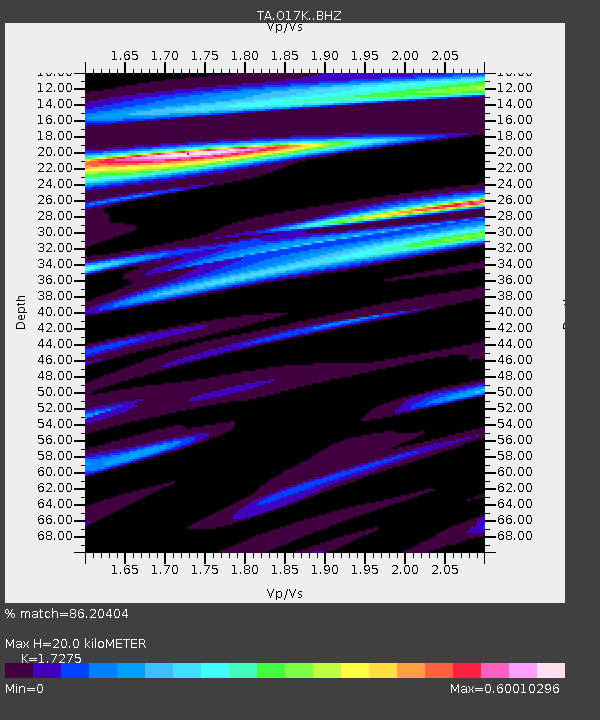
| Estimated Moho Depth: |
20.0 km |
| Estimated Crust Vp/Vs: |
1.73 |
| Assumed Crust Vp: |
6.276 km/s |
| Estimated Crust Vs: |
3.633 km/s |
| Estimated Crust Poisson's Ratio: |
0.25 |
|
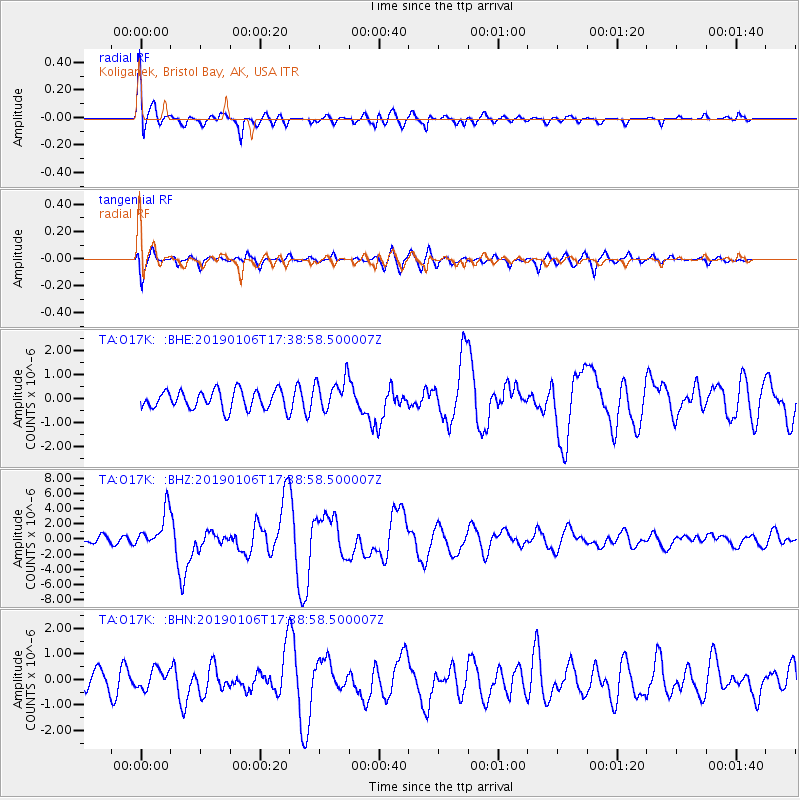
| Radial Match: |
86.20404 % |
| Radial Bump: |
400 |
| Transverse Match: |
83.941605 % |
| Transverse Bump: |
400 |
| SOD ConfigId: |
13570011 |
| Insert Time: |
2019-05-02 06:46:06.300 +0000 |
| GWidth: |
2.5 |
| Max Bumps: |
400 |
| Tol: |
0.001 |
|
Signal To Noise
| Channel | StoN | STA | LTA |
| TA:O17K: :BHZ:20190106T17:38:58.500007Z | 6.3034787 | 2.400718E-6 | 3.8085602E-7 |
| TA:O17K: :BHN:20190106T17:38:58.500007Z | 1.2504263 | 3.83364E-7 | 3.0658666E-7 |
| TA:O17K: :BHE:20190106T17:38:58.500007Z | 1.7971246 | 7.100828E-7 | 3.9512165E-7 |
| Arrivals |
| Ps | 2.4 SECOND |
| PpPs | 8.5 SECOND |
| PsPs/PpSs | 11 SECOND |


