You are here: Home > Network List > TA - USArray Transportable Network (new EarthScope stations) Stations List
> Station J19A Crowheart, WY, USA > Earthquake Result Viewer
J19A Crowheart, WY, USA - Earthquake Result Viewer
| Earthquake location: |
Kuril Islands |
| Earthquake latitude/longitude: |
50.8/155.0 |
| Earthquake time(UTC): |
2009/04/21 (111) 05:26:11 GMT |
| Earthquake Depth: |
152 km |
| Earthquake Magnitude: |
6.0 MB, 6.2 MW, 6.2 MW |
| Earthquake Catalog/Contributor: |
WHDF/NEIC |
|
| Network: |
TA USArray Transportable Network (new EarthScope stations) |
| Station: |
J19A Crowheart, WY, USA |
| Lat/Lon: |
43.26 N/109.05 W |
| Elevation: |
1782 m |
|
| Distance: |
61.3 deg |
| Az: |
55.923 deg |
| Baz: |
314.026 deg |
| Ray Param: |
0.060512222 |
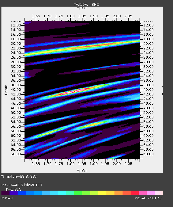
| Estimated Moho Depth: |
40.5 km |
| Estimated Crust Vp/Vs: |
1.82 |
| Assumed Crust Vp: |
6.161 km/s |
| Estimated Crust Vs: |
3.394 km/s |
| Estimated Crust Poisson's Ratio: |
0.28 |
|
| Radial Match: |
88.87337 % |
| Radial Bump: |
400 |
| Transverse Match: |
85.79457 % |
| Transverse Bump: |
400 |
| SOD ConfigId: |
2760 |
| Insert Time: |
2010-03-06 19:19:03.764 +0000 |
| GWidth: |
2.5 |
| Max Bumps: |
400 |
| Tol: |
0.001 |
|
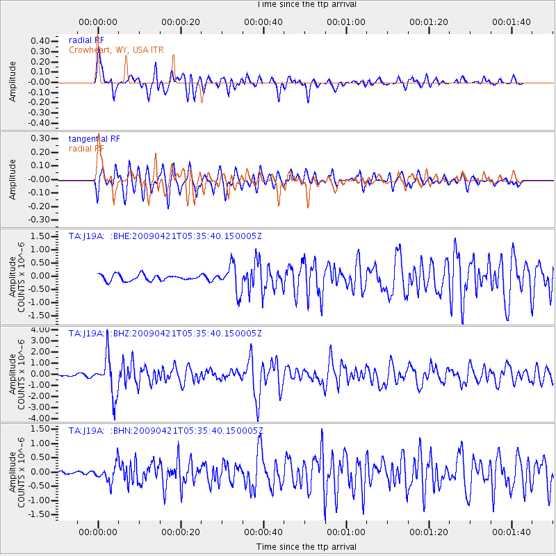
Signal To Noise
| Channel | StoN | STA | LTA |
| TA:J19A: :BHZ:20090421T05:35:40.150005Z | 13.504285 | 1.8093328E-6 | 1.3398213E-7 |
| TA:J19A: :BHN:20090421T05:35:40.150005Z | 4.611547 | 3.1216902E-7 | 6.769291E-8 |
| TA:J19A: :BHE:20090421T05:35:40.150005Z | 4.735354 | 5.3470035E-7 | 1.12916666E-7 |
| Arrivals |
| Ps | 5.6 SECOND |
| PpPs | 18 SECOND |
| PsPs/PpSs | 23 SECOND |


