You are here: Home > Network List > US - United States National Seismic Network Stations List
> Station HAWA Hanford, Washington, USA > Earthquake Result Viewer
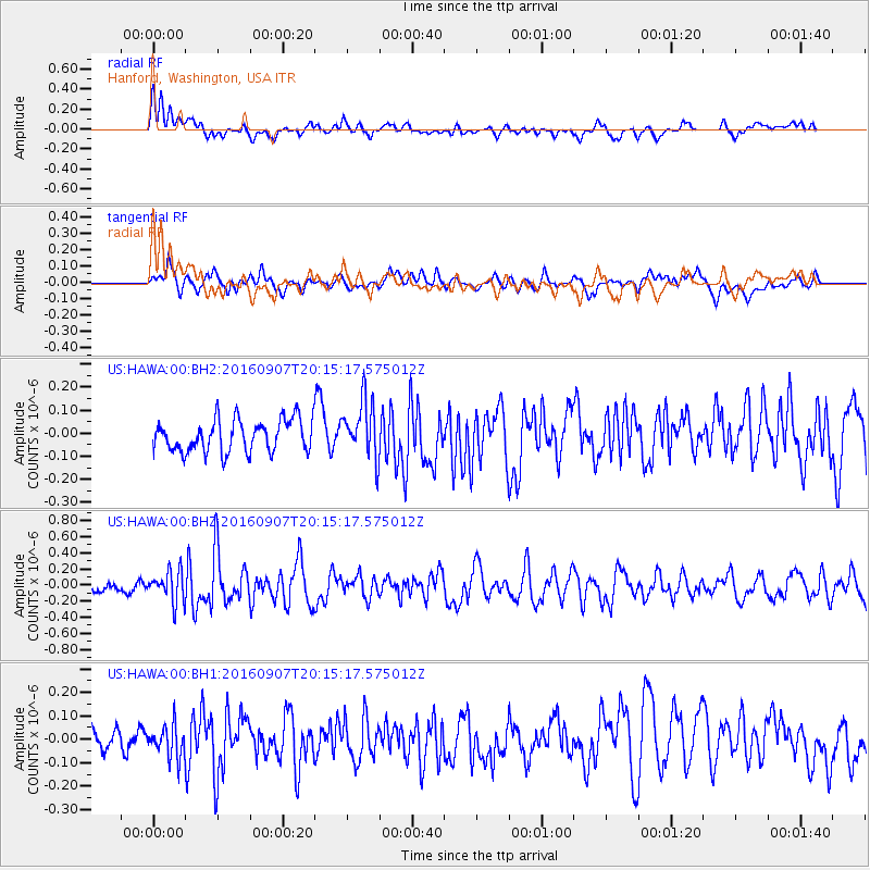
HAWA Hanford, Washington, USA - Earthquake Result Viewer
*The percent match for this event was below the threshold and hence no stack was calculated.
| Earthquake location: |
Komandorskiye Ostrova Region |
| Earthquake latitude/longitude: |
54.6/168.6 |
| Earthquake time(UTC): |
2016/09/07 (251) 20:07:36 GMT |
| Earthquake Depth: |
10 km |
| Earthquake Magnitude: |
5.5 MB |
| Earthquake Catalog/Contributor: |
NEIC PDE/NEIC COMCAT |
|
| Network: |
US United States National Seismic Network |
| Station: |
HAWA Hanford, Washington, USA |
| Lat/Lon: |
46.39 N/119.53 W |
| Elevation: |
364 m |
|
| Distance: |
44.6 deg |
| Az: |
69.587 deg |
| Baz: |
307.97 deg |
| Ray Param: |
$rayparam |
*The percent match for this event was below the threshold and hence was not used in the summary stack. |
|
| Radial Match: |
63.070755 % |
| Radial Bump: |
400 |
| Transverse Match: |
54.816463 % |
| Transverse Bump: |
400 |
| SOD ConfigId: |
1634031 |
| Insert Time: |
2016-09-21 20:18:33.805 +0000 |
| GWidth: |
2.5 |
| Max Bumps: |
400 |
| Tol: |
0.001 |
|
Signal To Noise
| Channel | StoN | STA | LTA |
| US:HAWA:00:BHZ:20160907T20:15:17.575012Z | 1.8046767 | 1.9171954E-7 | 1.0623484E-7 |
| US:HAWA:00:BH1:20160907T20:15:17.575012Z | 1.1928892 | 6.579355E-8 | 5.5154786E-8 |
| US:HAWA:00:BH2:20160907T20:15:17.575012Z | 1.8044337 | 1.2596558E-7 | 6.980893E-8 |
| Arrivals |
| Ps | |
| PpPs | |
| PsPs/PpSs | |


