You are here: Home > Network List > TA - USArray Transportable Network (new EarthScope stations) Stations List
> Station F21K Alatna River, AK, USA > Earthquake Result Viewer
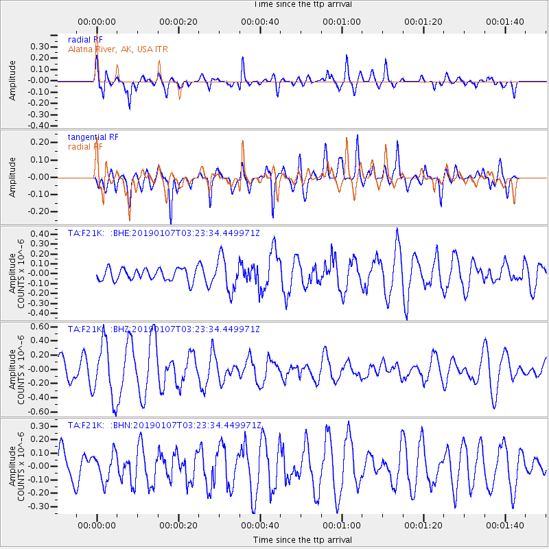
F21K Alatna River, AK, USA - Earthquake Result Viewer
*The percent match for this event was below the threshold and hence no stack was calculated.
| Earthquake location: |
Mindanao, Philippines |
| Earthquake latitude/longitude: |
7.9/121.9 |
| Earthquake time(UTC): |
2019/01/07 (007) 03:11:55 GMT |
| Earthquake Depth: |
35 km |
| Earthquake Magnitude: |
5.5 Mww |
| Earthquake Catalog/Contributor: |
NEIC PDE/us |
|
| Network: |
TA USArray Transportable Network (new EarthScope stations) |
| Station: |
F21K Alatna River, AK, USA |
| Lat/Lon: |
67.22 N/153.48 W |
| Elevation: |
597 m |
|
| Distance: |
80.7 deg |
| Az: |
23.13 deg |
| Baz: |
268.085 deg |
| Ray Param: |
$rayparam |
*The percent match for this event was below the threshold and hence was not used in the summary stack. |
|
| Radial Match: |
56.55591 % |
| Radial Bump: |
400 |
| Transverse Match: |
57.457153 % |
| Transverse Bump: |
388 |
| SOD ConfigId: |
13570011 |
| Insert Time: |
2019-05-02 06:50:18.288 +0000 |
| GWidth: |
2.5 |
| Max Bumps: |
400 |
| Tol: |
0.001 |
|
Signal To Noise
| Channel | StoN | STA | LTA |
| TA:F21K: :BHZ:20190107T03:23:34.449971Z | 2.212547 | 3.9978363E-7 | 1.8068933E-7 |
| TA:F21K: :BHN:20190107T03:23:34.449971Z | 0.78143984 | 1.05124485E-7 | 1.3452666E-7 |
| TA:F21K: :BHE:20190107T03:23:34.449971Z | 2.8607364 | 1.7244957E-7 | 6.028153E-8 |
| Arrivals |
| Ps | |
| PpPs | |
| PsPs/PpSs | |


