You are here: Home > Network List > TA - USArray Transportable Network (new EarthScope stations) Stations List
> Station A21K Barrow, AK, USA > Earthquake Result Viewer
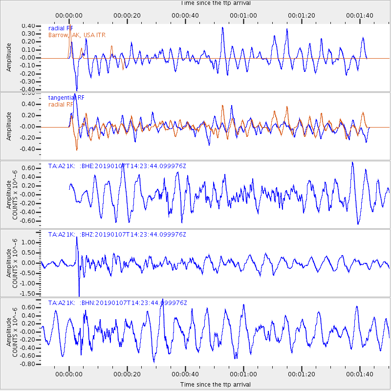
A21K Barrow, AK, USA - Earthquake Result Viewer
*The percent match for this event was below the threshold and hence no stack was calculated.
| Earthquake location: |
Northern Molucca Sea |
| Earthquake latitude/longitude: |
2.4/126.8 |
| Earthquake time(UTC): |
2019/01/07 (007) 14:11:52 GMT |
| Earthquake Depth: |
46 km |
| Earthquake Magnitude: |
5.5 mb |
| Earthquake Catalog/Contributor: |
NEIC PDE/us |
|
| Network: |
TA USArray Transportable Network (new EarthScope stations) |
| Station: |
A21K Barrow, AK, USA |
| Lat/Lon: |
71.32 N/156.62 W |
| Elevation: |
577 m |
|
| Distance: |
83.4 deg |
| Az: |
18.389 deg |
| Baz: |
258.045 deg |
| Ray Param: |
$rayparam |
*The percent match for this event was below the threshold and hence was not used in the summary stack. |
|
| Radial Match: |
66.95459 % |
| Radial Bump: |
400 |
| Transverse Match: |
60.2683 % |
| Transverse Bump: |
400 |
| SOD ConfigId: |
13570011 |
| Insert Time: |
2019-05-02 06:53:40.945 +0000 |
| GWidth: |
2.5 |
| Max Bumps: |
400 |
| Tol: |
0.001 |
|
Signal To Noise
| Channel | StoN | STA | LTA |
| TA:A21K: :BHZ:20190107T14:23:44.099976Z | 3.1331153 | 4.9091875E-7 | 1.5668711E-7 |
| TA:A21K: :BHN:20190107T14:23:44.099976Z | 1.1709327 | 2.3733573E-7 | 2.0268948E-7 |
| TA:A21K: :BHE:20190107T14:23:44.099976Z | 0.546192 | 1.6531735E-7 | 3.0267262E-7 |
| Arrivals |
| Ps | |
| PpPs | |
| PsPs/PpSs | |


