You are here: Home > Network List > TA - USArray Transportable Network (new EarthScope stations) Stations List
> Station J19A Crowheart, WY, USA > Earthquake Result Viewer
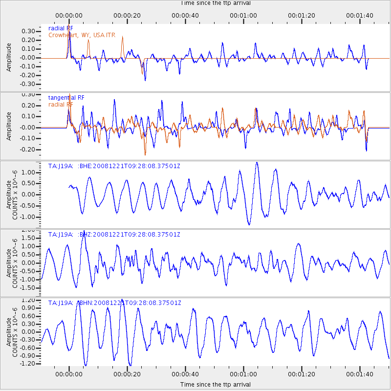
J19A Crowheart, WY, USA - Earthquake Result Viewer
*The percent match for this event was below the threshold and hence no stack was calculated.
| Earthquake location: |
Off East Coast Of Honshu, Japan |
| Earthquake latitude/longitude: |
36.5/142.3 |
| Earthquake time(UTC): |
2008/12/21 (356) 09:16:44 GMT |
| Earthquake Depth: |
13 km |
| Earthquake Magnitude: |
5.6 MB, 5.7 MS, 5.9 MW, 5.9 MW |
| Earthquake Catalog/Contributor: |
WHDF/NEIC |
|
| Network: |
TA USArray Transportable Network (new EarthScope stations) |
| Station: |
J19A Crowheart, WY, USA |
| Lat/Lon: |
43.26 N/109.05 W |
| Elevation: |
1782 m |
|
| Distance: |
77.5 deg |
| Az: |
45.161 deg |
| Baz: |
308.579 deg |
| Ray Param: |
$rayparam |
*The percent match for this event was below the threshold and hence was not used in the summary stack. |
|
| Radial Match: |
64.858444 % |
| Radial Bump: |
331 |
| Transverse Match: |
53.291553 % |
| Transverse Bump: |
400 |
| SOD ConfigId: |
2658 |
| Insert Time: |
2010-03-06 19:20:38.739 +0000 |
| GWidth: |
2.5 |
| Max Bumps: |
400 |
| Tol: |
0.001 |
|
Signal To Noise
| Channel | StoN | STA | LTA |
| TA:J19A: :BHZ:20081221T09:28:08.37501Z | 2.0450027 | 9.642675E-7 | 4.715238E-7 |
| TA:J19A: :BHN:20081221T09:28:08.37501Z | 1.795202 | 6.8319906E-7 | 3.8056947E-7 |
| TA:J19A: :BHE:20081221T09:28:08.37501Z | 0.85372925 | 3.9398236E-7 | 4.6148395E-7 |
| Arrivals |
| Ps | |
| PpPs | |
| PsPs/PpSs | |


