You are here: Home > Network List > TA - USArray Transportable Network (new EarthScope stations) Stations List
> Station E20K Nigu River, AK, USA > Earthquake Result Viewer
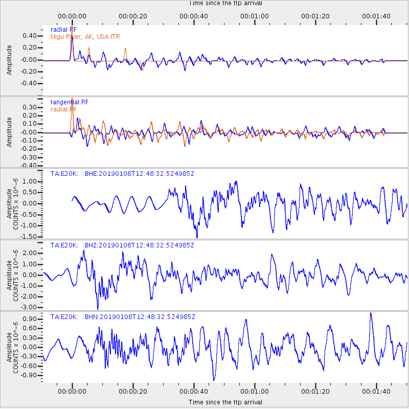
E20K Nigu River, AK, USA - Earthquake Result Viewer
*The percent match for this event was below the threshold and hence no stack was calculated.
| Earthquake location: |
Kyushu, Japan |
| Earthquake latitude/longitude: |
30.6/131.0 |
| Earthquake time(UTC): |
2019/01/08 (008) 12:39:31 GMT |
| Earthquake Depth: |
35 km |
| Earthquake Magnitude: |
6.3 Mww |
| Earthquake Catalog/Contributor: |
NEIC PDE/us |
|
| Network: |
TA USArray Transportable Network (new EarthScope stations) |
| Station: |
E20K Nigu River, AK, USA |
| Lat/Lon: |
68.26 N/156.19 W |
| Elevation: |
866 m |
|
| Distance: |
55.6 deg |
| Az: |
25.553 deg |
| Baz: |
266.644 deg |
| Ray Param: |
$rayparam |
*The percent match for this event was below the threshold and hence was not used in the summary stack. |
|
| Radial Match: |
75.246284 % |
| Radial Bump: |
400 |
| Transverse Match: |
72.10771 % |
| Transverse Bump: |
390 |
| SOD ConfigId: |
13570011 |
| Insert Time: |
2019-05-02 07:08:29.868 +0000 |
| GWidth: |
2.5 |
| Max Bumps: |
400 |
| Tol: |
0.001 |
|
Signal To Noise
| Channel | StoN | STA | LTA |
| TA:E20K: :BHZ:20190108T12:48:32.524985Z | 5.006451 | 1.1582378E-6 | 2.3134906E-7 |
| TA:E20K: :BHN:20190108T12:48:32.524985Z | 0.89458203 | 2.460067E-7 | 2.749962E-7 |
| TA:E20K: :BHE:20190108T12:48:32.524985Z | 1.8863062 | 4.0703983E-7 | 2.1578671E-7 |
| Arrivals |
| Ps | |
| PpPs | |
| PsPs/PpSs | |


