You are here: Home > Network List > TA - USArray Transportable Network (new EarthScope stations) Stations List
> Station F21K Alatna River, AK, USA > Earthquake Result Viewer
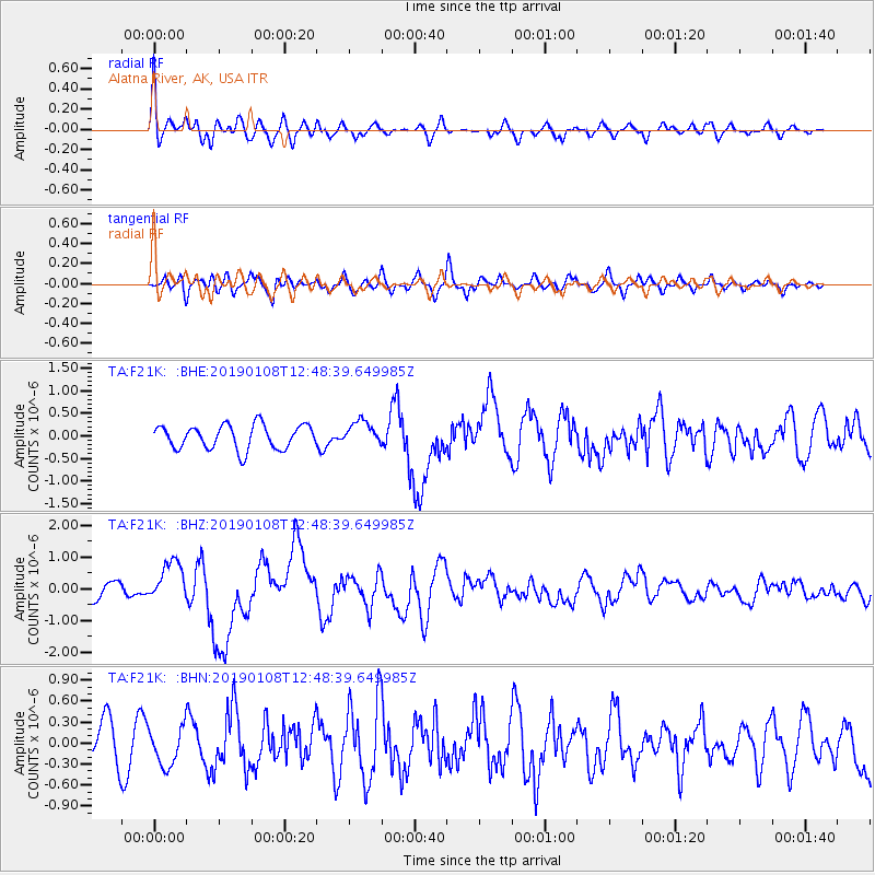
F21K Alatna River, AK, USA - Earthquake Result Viewer
*The percent match for this event was below the threshold and hence no stack was calculated.
| Earthquake location: |
Kyushu, Japan |
| Earthquake latitude/longitude: |
30.6/131.0 |
| Earthquake time(UTC): |
2019/01/08 (008) 12:39:31 GMT |
| Earthquake Depth: |
35 km |
| Earthquake Magnitude: |
6.3 Mww |
| Earthquake Catalog/Contributor: |
NEIC PDE/us |
|
| Network: |
TA USArray Transportable Network (new EarthScope stations) |
| Station: |
F21K Alatna River, AK, USA |
| Lat/Lon: |
67.22 N/153.48 W |
| Elevation: |
597 m |
|
| Distance: |
56.6 deg |
| Az: |
26.843 deg |
| Baz: |
269.866 deg |
| Ray Param: |
$rayparam |
*The percent match for this event was below the threshold and hence was not used in the summary stack. |
|
| Radial Match: |
64.16039 % |
| Radial Bump: |
400 |
| Transverse Match: |
65.041756 % |
| Transverse Bump: |
400 |
| SOD ConfigId: |
13570011 |
| Insert Time: |
2019-05-02 07:08:38.345 +0000 |
| GWidth: |
2.5 |
| Max Bumps: |
400 |
| Tol: |
0.001 |
|
Signal To Noise
| Channel | StoN | STA | LTA |
| TA:F21K: :BHZ:20190108T12:48:39.649985Z | 2.0741816 | 6.507867E-7 | 3.137559E-7 |
| TA:F21K: :BHN:20190108T12:48:39.649985Z | 1.0574735 | 2.749281E-7 | 2.5998582E-7 |
| TA:F21K: :BHE:20190108T12:48:39.649985Z | 0.9902738 | 2.626539E-7 | 2.6523364E-7 |
| Arrivals |
| Ps | |
| PpPs | |
| PsPs/PpSs | |


