You are here: Home > Network List > TA - USArray Transportable Network (new EarthScope stations) Stations List
> Station B22A Reddig Ranch South, Frazer, MT, USA > Earthquake Result Viewer
B22A Reddig Ranch South, Frazer, MT, USA - Earthquake Result Viewer

| Earthquake location: |
Southeast Of Honshu, Japan |
| Earthquake latitude/longitude: |
32.8/140.4 |
| Earthquake time(UTC): |
2009/08/12 (224) 22:48:51 GMT |
| Earthquake Depth: |
53 km |
| Earthquake Magnitude: |
6.2 MB, 6.6 MW, 6.6 MW |
| Earthquake Catalog/Contributor: |
WHDF/NEIC |
|
| Network: |
TA USArray Transportable Network (new EarthScope stations) |
| Station: |
B22A Reddig Ranch South, Frazer, MT, USA |
| Lat/Lon: |
48.30 N/106.00 W |
| Elevation: |
836 m |
|
| Distance: |
79.8 deg |
| Az: |
38.431 deg |
| Baz: |
308.387 deg |
| Ray Param: |
0.048589114 |
| Estimated Moho Depth: |
41.0 km |
| Estimated Crust Vp/Vs: |
1.90 |
| Assumed Crust Vp: |
6.438 km/s |
| Estimated Crust Vs: |
3.388 km/s |
| Estimated Crust Poisson's Ratio: |
0.31 |
|
| Radial Match: |
93.85759 % |
| Radial Bump: |
358 |
| Transverse Match: |
81.64001 % |
| Transverse Bump: |
400 |
| SOD ConfigId: |
2622 |
| Insert Time: |
2010-03-06 19:21:09.312 +0000 |
| GWidth: |
2.5 |
| Max Bumps: |
400 |
| Tol: |
0.001 |
|
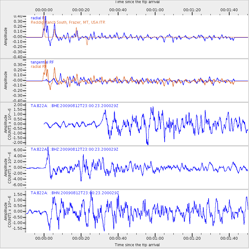
Signal To Noise
| Channel | StoN | STA | LTA |
| TA:B22A: :BHZ:20090812T23:00:23.200029Z | 32.867798 | 2.7907613E-6 | 8.4908685E-8 |
| TA:B22A: :BHN:20090812T23:00:23.200029Z | 5.990263 | 6.659964E-7 | 1.1117984E-7 |
| TA:B22A: :BHE:20090812T23:00:23.200029Z | 4.2977943 | 6.9770215E-7 | 1.6233959E-7 |
| Arrivals |
| Ps | 5.9 SECOND |
| PpPs | 18 SECOND |
| PsPs/PpSs | 24 SECOND |


