You are here: Home > Network List > TA - USArray Transportable Network (new EarthScope stations) Stations List
> Station B22A Reddig Ranch South, Frazer, MT, USA > Earthquake Result Viewer
B22A Reddig Ranch South, Frazer, MT, USA - Earthquake Result Viewer
| Earthquake location: |
Norwegian Sea |
| Earthquake latitude/longitude: |
72.2/0.9 |
| Earthquake time(UTC): |
2009/08/20 (232) 06:35:04 GMT |
| Earthquake Depth: |
6.0 km |
| Earthquake Magnitude: |
5.9 MB, 5.7 MS, 6.0 MW, 6.0 MW |
| Earthquake Catalog/Contributor: |
WHDF/NEIC |
|
| Network: |
TA USArray Transportable Network (new EarthScope stations) |
| Station: |
B22A Reddig Ranch South, Frazer, MT, USA |
| Lat/Lon: |
48.30 N/106.00 W |
| Elevation: |
836 m |
|
| Distance: |
49.6 deg |
| Az: |
302.955 deg |
| Baz: |
22.737 deg |
| Ray Param: |
0.06862564 |
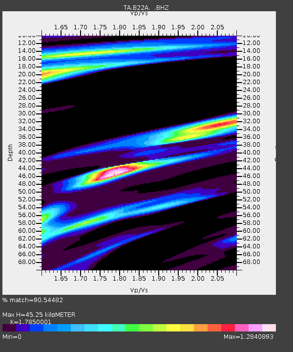
| Estimated Moho Depth: |
45.25 km |
| Estimated Crust Vp/Vs: |
1.79 |
| Assumed Crust Vp: |
6.438 km/s |
| Estimated Crust Vs: |
3.606 km/s |
| Estimated Crust Poisson's Ratio: |
0.27 |
|
| Radial Match: |
90.54482 % |
| Radial Bump: |
323 |
| Transverse Match: |
52.631924 % |
| Transverse Bump: |
400 |
| SOD ConfigId: |
2622 |
| Insert Time: |
2010-03-06 19:21:13.482 +0000 |
| GWidth: |
2.5 |
| Max Bumps: |
400 |
| Tol: |
0.001 |
|

Signal To Noise
| Channel | StoN | STA | LTA |
| TA:B22A: :BHZ:20090820T06:43:25.199012Z | 9.057609 | 1.1186826E-6 | 1.235075E-7 |
| TA:B22A: :BHN:20090820T06:43:25.199012Z | 2.8556857 | 4.0090805E-7 | 1.4038942E-7 |
| TA:B22A: :BHE:20090820T06:43:25.199012Z | 1.0179713 | 1.8064014E-7 | 1.7745113E-7 |
| Arrivals |
| Ps | 5.9 SECOND |
| PpPs | 18 SECOND |
| PsPs/PpSs | 24 SECOND |


