You are here: Home > Network List > TA - USArray Transportable Network (new EarthScope stations) Stations List
> Station B22A Reddig Ranch South, Frazer, MT, USA > Earthquake Result Viewer
B22A Reddig Ranch South, Frazer, MT, USA - Earthquake Result Viewer

| Earthquake location: |
Northern Mid-Atlantic Ridge |
| Earthquake latitude/longitude: |
23.9/-46.1 |
| Earthquake time(UTC): |
2009/06/06 (157) 20:33:28 GMT |
| Earthquake Depth: |
14 km |
| Earthquake Magnitude: |
6.0 MB, 5.7 MS, 6.0 MW, 6.0 MW |
| Earthquake Catalog/Contributor: |
WHDF/NEIC |
|
| Network: |
TA USArray Transportable Network (new EarthScope stations) |
| Station: |
B22A Reddig Ranch South, Frazer, MT, USA |
| Lat/Lon: |
48.30 N/106.00 W |
| Elevation: |
836 m |
|
| Distance: |
52.7 deg |
| Az: |
313.429 deg |
| Baz: |
95.285 deg |
| Ray Param: |
0.06658867 |
| Estimated Moho Depth: |
60.25 km |
| Estimated Crust Vp/Vs: |
1.99 |
| Assumed Crust Vp: |
6.438 km/s |
| Estimated Crust Vs: |
3.231 km/s |
| Estimated Crust Poisson's Ratio: |
0.33 |
|
| Radial Match: |
80.939575 % |
| Radial Bump: |
400 |
| Transverse Match: |
60.33278 % |
| Transverse Bump: |
400 |
| SOD ConfigId: |
2648 |
| Insert Time: |
2010-03-06 19:21:23.341 +0000 |
| GWidth: |
2.5 |
| Max Bumps: |
400 |
| Tol: |
0.001 |
|
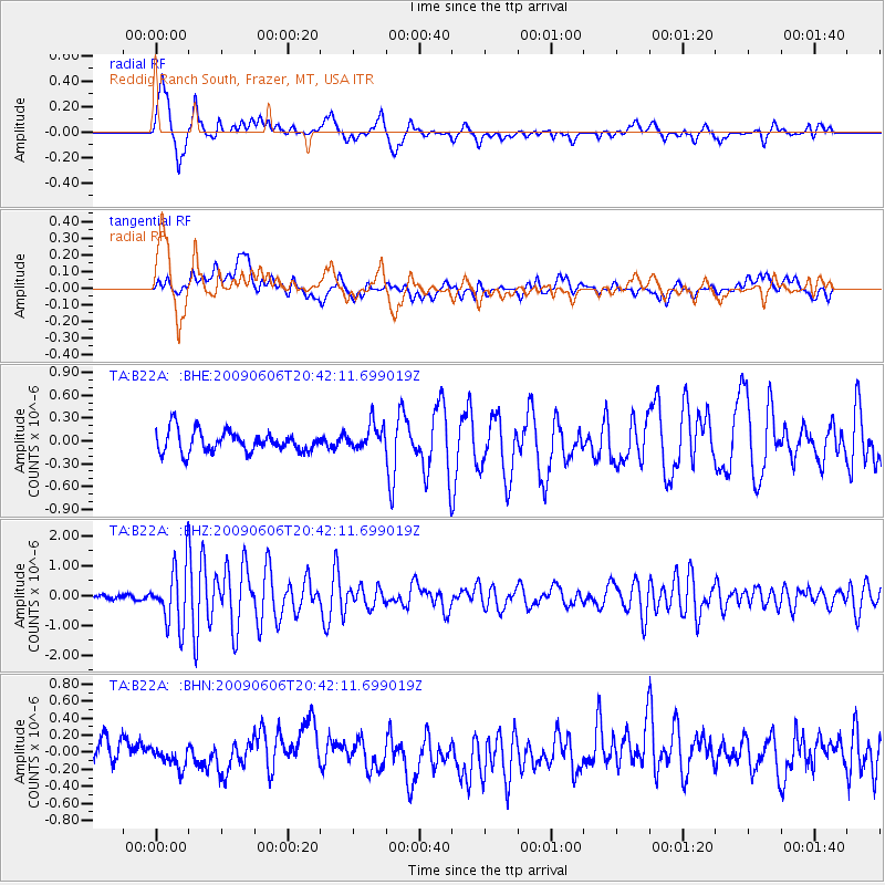
Signal To Noise
| Channel | StoN | STA | LTA |
| TA:B22A: :BHZ:20090606T20:42:11.699019Z | 14.9211855 | 9.803241E-7 | 6.570015E-8 |
| TA:B22A: :BHN:20090606T20:42:11.699019Z | 0.71276665 | 1.0480413E-7 | 1.4703849E-7 |
| TA:B22A: :BHE:20090606T20:42:11.699019Z | 1.1972927 | 1.6508986E-7 | 1.3788596E-7 |
| Arrivals |
| Ps | 9.8 SECOND |
| PpPs | 27 SECOND |
| PsPs/PpSs | 36 SECOND |


