You are here: Home > Network List > TA - USArray Transportable Network (new EarthScope stations) Stations List
> Station B22A Reddig Ranch South, Frazer, MT, USA > Earthquake Result Viewer
B22A Reddig Ranch South, Frazer, MT, USA - Earthquake Result Viewer
| Earthquake location: |
Kuril Islands |
| Earthquake latitude/longitude: |
46.0/151.4 |
| Earthquake time(UTC): |
2009/04/18 (108) 19:17:58 GMT |
| Earthquake Depth: |
35 km |
| Earthquake Magnitude: |
6.3 MB, 6.3 MS, 6.6 MW, 6.4 MW |
| Earthquake Catalog/Contributor: |
WHDF/NEIC |
|
| Network: |
TA USArray Transportable Network (new EarthScope stations) |
| Station: |
B22A Reddig Ranch South, Frazer, MT, USA |
| Lat/Lon: |
48.30 N/106.00 W |
| Elevation: |
836 m |
|
| Distance: |
64.4 deg |
| Az: |
46.287 deg |
| Baz: |
311.028 deg |
| Ray Param: |
0.058908813 |
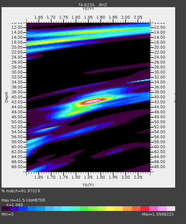
| Estimated Moho Depth: |
41.5 km |
| Estimated Crust Vp/Vs: |
1.87 |
| Assumed Crust Vp: |
6.438 km/s |
| Estimated Crust Vs: |
3.452 km/s |
| Estimated Crust Poisson's Ratio: |
0.30 |
|
| Radial Match: |
91.97019 % |
| Radial Bump: |
322 |
| Transverse Match: |
74.698265 % |
| Transverse Bump: |
400 |
| SOD ConfigId: |
2658 |
| Insert Time: |
2010-03-06 19:21:24.345 +0000 |
| GWidth: |
2.5 |
| Max Bumps: |
400 |
| Tol: |
0.001 |
|
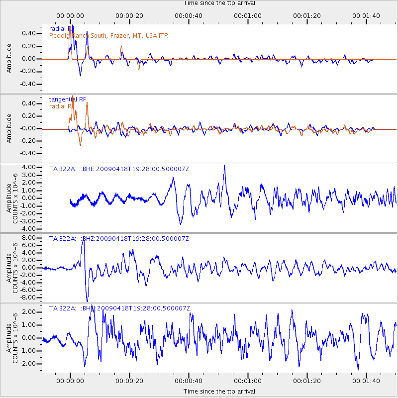
Signal To Noise
| Channel | StoN | STA | LTA |
| TA:B22A: :BHZ:20090418T19:28:00.500007Z | 16.100979 | 3.2265323E-6 | 2.0039356E-7 |
| TA:B22A: :BHN:20090418T19:28:00.500007Z | 2.5119991 | 6.6792E-7 | 2.658918E-7 |
| TA:B22A: :BHE:20090418T19:28:00.500007Z | 2.5614843 | 1.1181431E-6 | 4.3652156E-7 |
| Arrivals |
| Ps | 5.8 SECOND |
| PpPs | 18 SECOND |
| PsPs/PpSs | 24 SECOND |


