You are here: Home > Network List > TA - USArray Transportable Network (new EarthScope stations) Stations List
> Station B22A Reddig Ranch South, Frazer, MT, USA > Earthquake Result Viewer
B22A Reddig Ranch South, Frazer, MT, USA - Earthquake Result Viewer

| Earthquake location: |
Kuril Islands |
| Earthquake latitude/longitude: |
46.0/151.5 |
| Earthquake time(UTC): |
2009/04/07 (097) 04:23:33 GMT |
| Earthquake Depth: |
31 km |
| Earthquake Magnitude: |
6.5 MB, 6.8 MS, 6.9 MW, 6.9 MW |
| Earthquake Catalog/Contributor: |
WHDF/NEIC |
|
| Network: |
TA USArray Transportable Network (new EarthScope stations) |
| Station: |
B22A Reddig Ranch South, Frazer, MT, USA |
| Lat/Lon: |
48.30 N/106.00 W |
| Elevation: |
836 m |
|
| Distance: |
64.3 deg |
| Az: |
46.358 deg |
| Baz: |
310.99 deg |
| Ray Param: |
0.05897246 |
| Estimated Moho Depth: |
18.0 km |
| Estimated Crust Vp/Vs: |
1.67 |
| Assumed Crust Vp: |
6.438 km/s |
| Estimated Crust Vs: |
3.849 km/s |
| Estimated Crust Poisson's Ratio: |
0.22 |
|
| Radial Match: |
95.87525 % |
| Radial Bump: |
313 |
| Transverse Match: |
76.18524 % |
| Transverse Bump: |
400 |
| SOD ConfigId: |
2658 |
| Insert Time: |
2010-03-06 19:21:40.139 +0000 |
| GWidth: |
2.5 |
| Max Bumps: |
400 |
| Tol: |
0.001 |
|
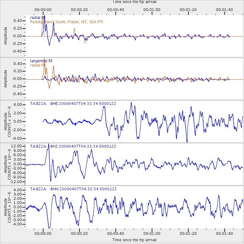
Signal To Noise
| Channel | StoN | STA | LTA |
| TA:B22A: :BHZ:20090407T04:33:34.600012Z | 39.451504 | 6.580726E-6 | 1.6680546E-7 |
| TA:B22A: :BHN:20090407T04:33:34.600012Z | 9.293388 | 2.4393528E-6 | 2.6248262E-7 |
| TA:B22A: :BHE:20090407T04:33:34.600012Z | 5.182286 | 1.7728424E-6 | 3.4209663E-7 |
| Arrivals |
| Ps | 2.0 SECOND |
| PpPs | 7.1 SECOND |
| PsPs/PpSs | 9.1 SECOND |


