You are here: Home > Network List > TA - USArray Transportable Network (new EarthScope stations) Stations List
> Station C16K Lisburne Hills, AK, USA > Earthquake Result Viewer
C16K Lisburne Hills, AK, USA - Earthquake Result Viewer
| Earthquake location: |
Vanuatu Islands |
| Earthquake latitude/longitude: |
-13.4/166.8 |
| Earthquake time(UTC): |
2019/01/15 (015) 18:06:34 GMT |
| Earthquake Depth: |
35 km |
| Earthquake Magnitude: |
6.6 mww |
| Earthquake Catalog/Contributor: |
NEIC PDE/us |
|
| Network: |
TA USArray Transportable Network (new EarthScope stations) |
| Station: |
C16K Lisburne Hills, AK, USA |
| Lat/Lon: |
68.27 N/165.34 W |
| Elevation: |
102 m |
|
| Distance: |
83.8 deg |
| Az: |
10.063 deg |
| Baz: |
207.18 deg |
| Ray Param: |
0.04585972 |
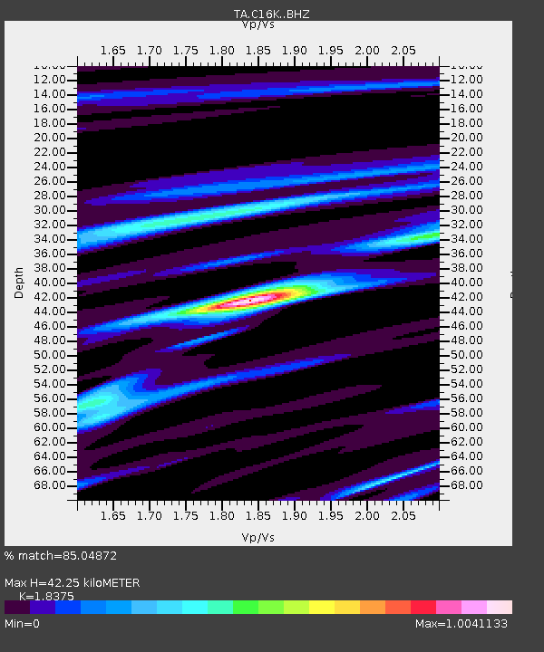
| Estimated Moho Depth: |
42.25 km |
| Estimated Crust Vp/Vs: |
1.84 |
| Assumed Crust Vp: |
5.906 km/s |
| Estimated Crust Vs: |
3.214 km/s |
| Estimated Crust Poisson's Ratio: |
0.29 |
|
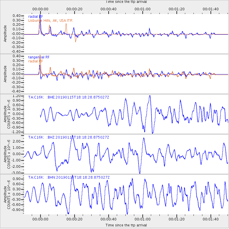
| Radial Match: |
85.04872 % |
| Radial Bump: |
344 |
| Transverse Match: |
53.086723 % |
| Transverse Bump: |
400 |
| SOD ConfigId: |
13570011 |
| Insert Time: |
2019-05-02 07:33:24.619 +0000 |
| GWidth: |
2.5 |
| Max Bumps: |
400 |
| Tol: |
0.001 |
|
Signal To Noise
| Channel | StoN | STA | LTA |
| TA:C16K: :BHZ:20190115T18:18:28.875027Z | 2.697877 | 7.0124696E-7 | 2.5992549E-7 |
| TA:C16K: :BHN:20190115T18:18:28.875027Z | 1.5731196 | 3.8621098E-7 | 2.455064E-7 |
| TA:C16K: :BHE:20190115T18:18:28.875027Z | 1.0853814 | 2.500403E-7 | 2.3037092E-7 |
| Arrivals |
| Ps | 6.1 SECOND |
| PpPs | 20 SECOND |
| PsPs/PpSs | 26 SECOND |


