You are here: Home > Network List > TA - USArray Transportable Network (new EarthScope stations) Stations List
> Station E18K Tukpahlearik Creek, AK, USA > Earthquake Result Viewer
E18K Tukpahlearik Creek, AK, USA - Earthquake Result Viewer
| Earthquake location: |
Vanuatu Islands |
| Earthquake latitude/longitude: |
-13.4/166.8 |
| Earthquake time(UTC): |
2019/01/15 (015) 18:06:34 GMT |
| Earthquake Depth: |
35 km |
| Earthquake Magnitude: |
6.6 mww |
| Earthquake Catalog/Contributor: |
NEIC PDE/us |
|
| Network: |
TA USArray Transportable Network (new EarthScope stations) |
| Station: |
E18K Tukpahlearik Creek, AK, USA |
| Lat/Lon: |
67.42 N/160.60 W |
| Elevation: |
297 m |
|
| Distance: |
84.0 deg |
| Az: |
12.061 deg |
| Baz: |
211.78 deg |
| Ray Param: |
0.04576188 |
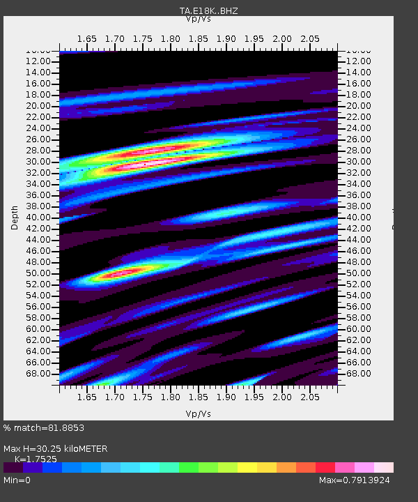
| Estimated Moho Depth: |
30.25 km |
| Estimated Crust Vp/Vs: |
1.75 |
| Assumed Crust Vp: |
6.276 km/s |
| Estimated Crust Vs: |
3.581 km/s |
| Estimated Crust Poisson's Ratio: |
0.26 |
|
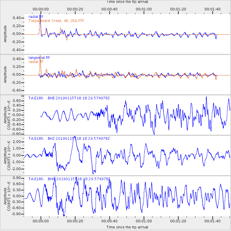
| Radial Match: |
81.8853 % |
| Radial Bump: |
400 |
| Transverse Match: |
59.741966 % |
| Transverse Bump: |
400 |
| SOD ConfigId: |
13570011 |
| Insert Time: |
2019-05-02 07:33:36.982 +0000 |
| GWidth: |
2.5 |
| Max Bumps: |
400 |
| Tol: |
0.001 |
|
Signal To Noise
| Channel | StoN | STA | LTA |
| TA:E18K: :BHZ:20190115T18:18:29.574978Z | 2.7962239 | 5.1858683E-7 | 1.8545968E-7 |
| TA:E18K: :BHN:20190115T18:18:29.574978Z | 2.1558273 | 3.5283878E-7 | 1.6366748E-7 |
| TA:E18K: :BHE:20190115T18:18:29.574978Z | 0.7887917 | 1.0558712E-7 | 1.3385932E-7 |
| Arrivals |
| Ps | 3.7 SECOND |
| PpPs | 13 SECOND |
| PsPs/PpSs | 17 SECOND |


