You are here: Home > Network List > TA - USArray Transportable Network (new EarthScope stations) Stations List
> Station G21K Allakaket, AK, USA > Earthquake Result Viewer
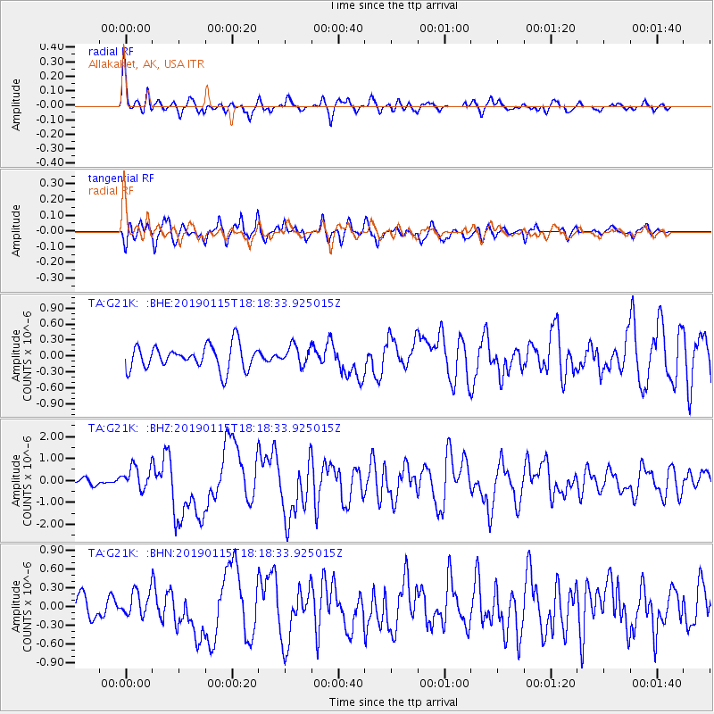
G21K Allakaket, AK, USA - Earthquake Result Viewer
*The percent match for this event was below the threshold and hence no stack was calculated.
| Earthquake location: |
Vanuatu Islands |
| Earthquake latitude/longitude: |
-13.4/166.8 |
| Earthquake time(UTC): |
2019/01/15 (015) 18:06:34 GMT |
| Earthquake Depth: |
35 km |
| Earthquake Magnitude: |
6.6 mww |
| Earthquake Catalog/Contributor: |
NEIC PDE/us |
|
| Network: |
TA USArray Transportable Network (new EarthScope stations) |
| Station: |
G21K Allakaket, AK, USA |
| Lat/Lon: |
66.52 N/153.51 W |
| Elevation: |
446 m |
|
| Distance: |
84.8 deg |
| Az: |
14.879 deg |
| Baz: |
218.581 deg |
| Ray Param: |
$rayparam |
*The percent match for this event was below the threshold and hence was not used in the summary stack. |
|
| Radial Match: |
72.74486 % |
| Radial Bump: |
385 |
| Transverse Match: |
79.842064 % |
| Transverse Bump: |
400 |
| SOD ConfigId: |
13570011 |
| Insert Time: |
2019-05-02 07:33:50.691 +0000 |
| GWidth: |
2.5 |
| Max Bumps: |
400 |
| Tol: |
0.001 |
|
Signal To Noise
| Channel | StoN | STA | LTA |
| TA:G21K: :BHZ:20190115T18:18:33.925015Z | 5.186874 | 5.4439477E-7 | 1.0495624E-7 |
| TA:G21K: :BHN:20190115T18:18:33.925015Z | 0.9869917 | 2.1213582E-7 | 2.1493172E-7 |
| TA:G21K: :BHE:20190115T18:18:33.925015Z | 0.83208495 | 1.8731359E-7 | 2.2511354E-7 |
| Arrivals |
| Ps | |
| PpPs | |
| PsPs/PpSs | |


