You are here: Home > Network List > TA - USArray Transportable Network (new EarthScope stations) Stations List
> Station A23A Redstone, MT, USA > Earthquake Result Viewer
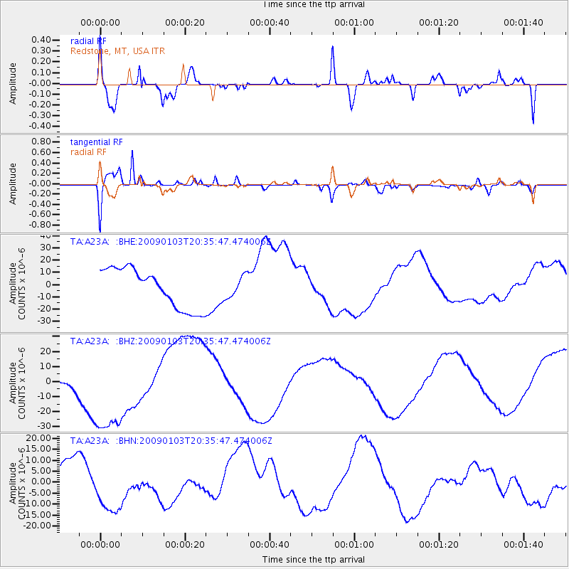
A23A Redstone, MT, USA - Earthquake Result Viewer
*The percent match for this event was below the threshold and hence no stack was calculated.
| Earthquake location: |
Hindu Kush Region, Afghanistan |
| Earthquake latitude/longitude: |
36.4/70.7 |
| Earthquake time(UTC): |
2009/01/03 (003) 20:23:20 GMT |
| Earthquake Depth: |
205 km |
| Earthquake Magnitude: |
5.8 MB |
| Earthquake Catalog/Contributor: |
WHDF/NEIC |
|
| Network: |
TA USArray Transportable Network (new EarthScope stations) |
| Station: |
A23A Redstone, MT, USA |
| Lat/Lon: |
48.96 N/104.88 W |
| Elevation: |
665 m |
|
| Distance: |
94.9 deg |
| Az: |
357.105 deg |
| Baz: |
3.543 deg |
| Ray Param: |
$rayparam |
*The percent match for this event was below the threshold and hence was not used in the summary stack. |
|
| Radial Match: |
56.037464 % |
| Radial Bump: |
400 |
| Transverse Match: |
87.97564 % |
| Transverse Bump: |
400 |
| SOD ConfigId: |
2834 |
| Insert Time: |
2010-03-06 19:24:11.769 +0000 |
| GWidth: |
2.5 |
| Max Bumps: |
400 |
| Tol: |
0.001 |
|
Signal To Noise
| Channel | StoN | STA | LTA |
| TA:A23A: :BHZ:20090103T20:35:47.474006Z | 4.627309 | 3.7831196E-5 | 8.175637E-6 |
| TA:A23A: :BHN:20090103T20:35:47.474006Z | 0.97660357 | 1.2076287E-5 | 1.2365598E-5 |
| TA:A23A: :BHE:20090103T20:35:47.474006Z | 0.55571747 | 8.902245E-6 | 1.6019372E-5 |
| Arrivals |
| Ps | |
| PpPs | |
| PsPs/PpSs | |


