You are here: Home > Network List > TA - USArray Transportable Network (new EarthScope stations) Stations List
> Station A23A Redstone, MT, USA > Earthquake Result Viewer
A23A Redstone, MT, USA - Earthquake Result Viewer
*The percent match for this event was below the threshold and hence no stack was calculated.
| Earthquake location: |
North Of Ascension Island |
| Earthquake latitude/longitude: |
-1.2/-13.9 |
| Earthquake time(UTC): |
2008/11/22 (327) 18:49:42 GMT |
| Earthquake Depth: |
10 km |
| Earthquake Magnitude: |
5.9 MB, 6.0 MS, 6.3 MW, 6.2 MW |
| Earthquake Catalog/Contributor: |
WHDF/NEIC |
|
| Network: |
TA USArray Transportable Network (new EarthScope stations) |
| Station: |
A23A Redstone, MT, USA |
| Lat/Lon: |
48.96 N/104.88 W |
| Elevation: |
665 m |
|
| Distance: |
91.5 deg |
| Az: |
318.757 deg |
| Baz: |
90.094 deg |
| Ray Param: |
$rayparam |
*The percent match for this event was below the threshold and hence was not used in the summary stack. |
|
| Radial Match: |
68.19333 % |
| Radial Bump: |
400 |
| Transverse Match: |
70.18869 % |
| Transverse Bump: |
330 |
| SOD ConfigId: |
2658 |
| Insert Time: |
2010-03-06 19:24:15.700 +0000 |
| GWidth: |
2.5 |
| Max Bumps: |
400 |
| Tol: |
0.001 |
|
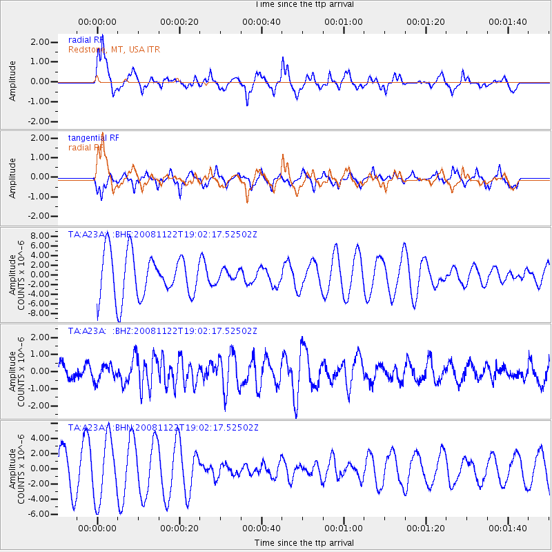
Signal To Noise
| Channel | StoN | STA | LTA |
| TA:A23A: :BHZ:20081122T19:02:17.52502Z | 0.5060651 | 4.5082732E-7 | 8.908486E-7 |
| TA:A23A: :BHN:20081122T19:02:17.52502Z | 1.5434872 | 4.135375E-6 | 2.6792416E-6 |
| TA:A23A: :BHE:20081122T19:02:17.52502Z | 0.25125852 | 1.144428E-6 | 4.554782E-6 |
| Arrivals |
| Ps | |
| PpPs | |
| PsPs/PpSs | |


