You are here: Home > Network List > TA - USArray Transportable Network (new EarthScope stations) Stations List
> Station F20K Avaraart Lake, AK, USA > Earthquake Result Viewer
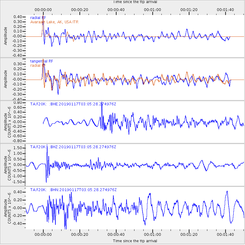
F20K Avaraart Lake, AK, USA - Earthquake Result Viewer
*The percent match for this event was below the threshold and hence no stack was calculated.
| Earthquake location: |
Nicobar Islands, India Region |
| Earthquake latitude/longitude: |
7.4/94.4 |
| Earthquake time(UTC): |
2019/01/17 (017) 02:53:07 GMT |
| Earthquake Depth: |
99 km |
| Earthquake Magnitude: |
5.4 Mww |
| Earthquake Catalog/Contributor: |
NEIC PDE/us |
|
| Network: |
TA USArray Transportable Network (new EarthScope stations) |
| Station: |
F20K Avaraart Lake, AK, USA |
| Lat/Lon: |
67.05 N/155.73 W |
| Elevation: |
136 m |
|
| Distance: |
90.8 deg |
| Az: |
21.644 deg |
| Baz: |
291.137 deg |
| Ray Param: |
$rayparam |
*The percent match for this event was below the threshold and hence was not used in the summary stack. |
|
| Radial Match: |
38.48101 % |
| Radial Bump: |
400 |
| Transverse Match: |
37.680527 % |
| Transverse Bump: |
400 |
| SOD ConfigId: |
13570011 |
| Insert Time: |
2019-05-02 07:43:48.985 +0000 |
| GWidth: |
2.5 |
| Max Bumps: |
400 |
| Tol: |
0.001 |
|
Signal To Noise
| Channel | StoN | STA | LTA |
| TA:F20K: :BHZ:20190117T03:05:28.274976Z | 6.2489395 | 5.7437376E-7 | 9.19154E-8 |
| TA:F20K: :BHN:20190117T03:05:28.274976Z | 1.080345 | 1.4909051E-7 | 1.3800268E-7 |
| TA:F20K: :BHE:20190117T03:05:28.274976Z | 3.2670758 | 2.639692E-7 | 8.079678E-8 |
| Arrivals |
| Ps | |
| PpPs | |
| PsPs/PpSs | |


