You are here: Home > Network List > TA - USArray Transportable Network (new EarthScope stations) Stations List
> Station A23A Redstone, MT, USA > Earthquake Result Viewer
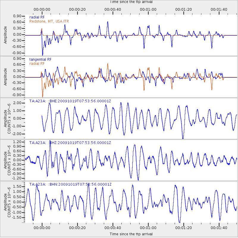
A23A Redstone, MT, USA - Earthquake Result Viewer
*The percent match for this event was below the threshold and hence no stack was calculated.
| Earthquake location: |
Samoa Islands Region |
| Earthquake latitude/longitude: |
-15.4/-173.0 |
| Earthquake time(UTC): |
2009/10/19 (292) 07:41:38 GMT |
| Earthquake Depth: |
10 km |
| Earthquake Magnitude: |
5.8 MW, 5.4 MS, 5.4 MB, 5.8 MW |
| Earthquake Catalog/Contributor: |
WHDF/NEIC |
|
| Network: |
TA USArray Transportable Network (new EarthScope stations) |
| Station: |
A23A Redstone, MT, USA |
| Lat/Lon: |
48.96 N/104.88 W |
| Elevation: |
665 m |
|
| Distance: |
87.8 deg |
| Az: |
37.732 deg |
| Baz: |
243.563 deg |
| Ray Param: |
$rayparam |
*The percent match for this event was below the threshold and hence was not used in the summary stack. |
|
| Radial Match: |
42.32294 % |
| Radial Bump: |
400 |
| Transverse Match: |
47.228916 % |
| Transverse Bump: |
400 |
| SOD ConfigId: |
2622 |
| Insert Time: |
2010-03-06 19:24:38.608 +0000 |
| GWidth: |
2.5 |
| Max Bumps: |
400 |
| Tol: |
0.001 |
|
Signal To Noise
| Channel | StoN | STA | LTA |
| TA:A23A: :BHZ:20091019T07:53:56.00001Z | 2.705833 | 6.1631835E-7 | 2.2777398E-7 |
| TA:A23A: :BHN:20091019T07:53:56.00001Z | 0.6834123 | 6.305904E-7 | 9.2270864E-7 |
| TA:A23A: :BHE:20091019T07:53:56.00001Z | 0.85941344 | 8.5608576E-7 | 9.96128E-7 |
| Arrivals |
| Ps | |
| PpPs | |
| PsPs/PpSs | |


