You are here: Home > Network List > CN - Canadian National Seismograph Network Stations List
> Station INK INUVIK, NT > Earthquake Result Viewer
INK INUVIK, NT - Earthquake Result Viewer
*The percent match for this event was below the threshold and hence no stack was calculated.
| Earthquake location: |
Bismarck Sea |
| Earthquake latitude/longitude: |
-3.2/146.4 |
| Earthquake time(UTC): |
2019/01/17 (017) 16:53:15 GMT |
| Earthquake Depth: |
10 km |
| Earthquake Magnitude: |
5.7 Mww |
| Earthquake Catalog/Contributor: |
NEIC PDE/us |
|
| Network: |
CN Canadian National Seismograph Network |
| Station: |
INK INUVIK, NT |
| Lat/Lon: |
68.31 N/133.53 W |
| Elevation: |
44 m |
|
| Distance: |
89.3 deg |
| Az: |
21.482 deg |
| Baz: |
259.567 deg |
| Ray Param: |
$rayparam |
*The percent match for this event was below the threshold and hence was not used in the summary stack. |
|
| Radial Match: |
56.571857 % |
| Radial Bump: |
400 |
| Transverse Match: |
51.156548 % |
| Transverse Bump: |
400 |
| SOD ConfigId: |
13570011 |
| Insert Time: |
2019-05-02 07:51:40.681 +0000 |
| GWidth: |
2.5 |
| Max Bumps: |
400 |
| Tol: |
0.001 |
|
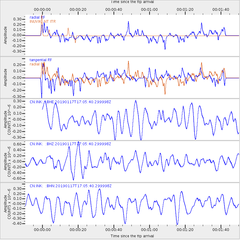
Signal To Noise
| Channel | StoN | STA | LTA |
| CN:INK: :BHZ:20190117T17:05:40.299998Z | 0.7671608 | 1.1688812E-7 | 1.5236456E-7 |
| CN:INK: :BHN:20190117T17:05:40.299998Z | 0.88521504 | 1.5664659E-7 | 1.7695879E-7 |
| CN:INK: :BHE:20190117T17:05:40.299998Z | 1.0209359 | 1.346015E-7 | 1.3184129E-7 |
| Arrivals |
| Ps | |
| PpPs | |
| PsPs/PpSs | |


