You are here: Home > Network List > TA - USArray Transportable Network (new EarthScope stations) Stations List
> Station A23A Redstone, MT, USA > Earthquake Result Viewer
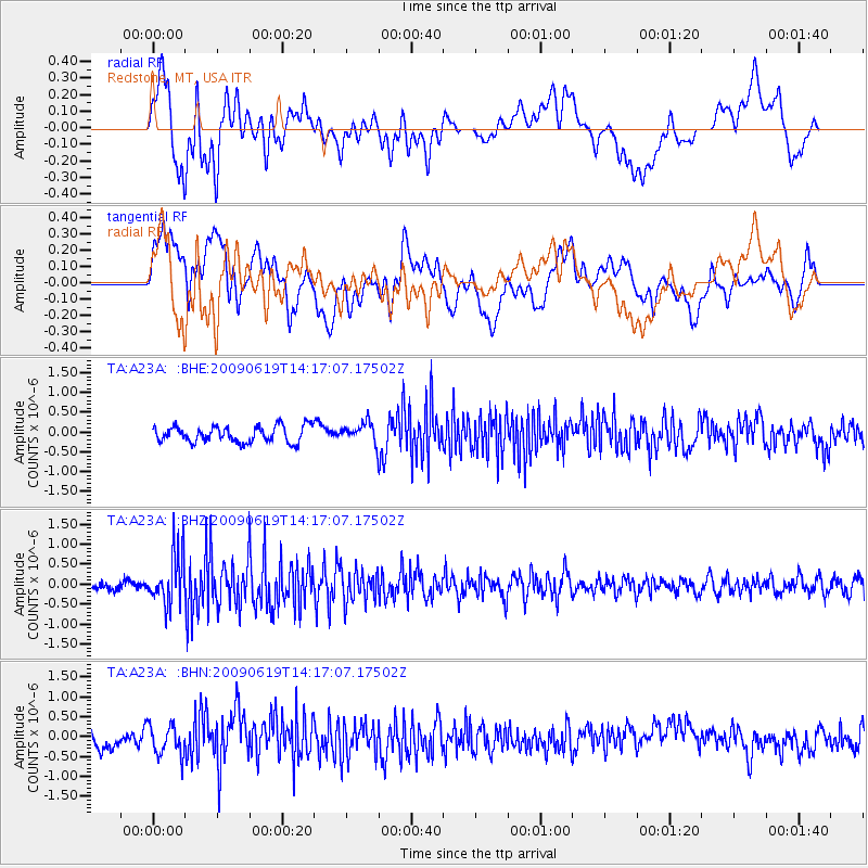
A23A Redstone, MT, USA - Earthquake Result Viewer
*The percent match for this event was below the threshold and hence no stack was calculated.
| Earthquake location: |
Eastern Mediterranean Sea |
| Earthquake latitude/longitude: |
35.4/28.5 |
| Earthquake time(UTC): |
2009/06/19 (170) 14:04:59 GMT |
| Earthquake Depth: |
28 km |
| Earthquake Magnitude: |
5.6 MB, 5.6 MS, 5.8 MW, 5.8 MW |
| Earthquake Catalog/Contributor: |
WHDF/NEIC |
|
| Network: |
TA USArray Transportable Network (new EarthScope stations) |
| Station: |
A23A Redstone, MT, USA |
| Lat/Lon: |
48.96 N/104.88 W |
| Elevation: |
665 m |
|
| Distance: |
86.4 deg |
| Az: |
331.289 deg |
| Baz: |
36.567 deg |
| Ray Param: |
$rayparam |
*The percent match for this event was below the threshold and hence was not used in the summary stack. |
|
| Radial Match: |
65.34217 % |
| Radial Bump: |
400 |
| Transverse Match: |
72.66519 % |
| Transverse Bump: |
400 |
| SOD ConfigId: |
2648 |
| Insert Time: |
2010-03-06 19:24:56.963 +0000 |
| GWidth: |
2.5 |
| Max Bumps: |
400 |
| Tol: |
0.001 |
|
Signal To Noise
| Channel | StoN | STA | LTA |
| TA:A23A: :BHZ:20090619T14:17:07.17502Z | 5.6558957 | 6.420892E-7 | 1.13525644E-7 |
| TA:A23A: :BHN:20090619T14:17:07.17502Z | 2.0615323 | 3.8065326E-7 | 1.846458E-7 |
| TA:A23A: :BHE:20090619T14:17:07.17502Z | 1.2555709 | 2.5556886E-7 | 2.0354794E-7 |
| Arrivals |
| Ps | |
| PpPs | |
| PsPs/PpSs | |


