You are here: Home > Network List > TA - USArray Transportable Network (new EarthScope stations) Stations List
> Station B18K Kokolik River, AK, USA > Earthquake Result Viewer
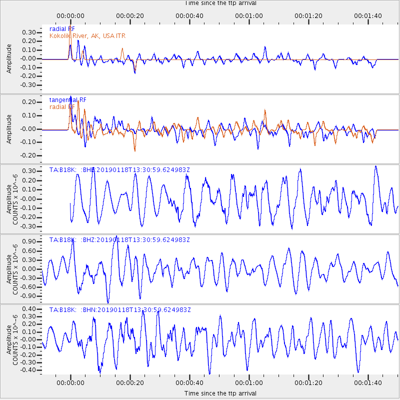
B18K Kokolik River, AK, USA - Earthquake Result Viewer
*The percent match for this event was below the threshold and hence no stack was calculated.
| Earthquake location: |
Vanuatu Islands |
| Earthquake latitude/longitude: |
-19.2/168.6 |
| Earthquake time(UTC): |
2019/01/18 (018) 13:18:32 GMT |
| Earthquake Depth: |
45 km |
| Earthquake Magnitude: |
6.0 Mww |
| Earthquake Catalog/Contributor: |
NEIC PDE/us |
|
| Network: |
TA USArray Transportable Network (new EarthScope stations) |
| Station: |
B18K Kokolik River, AK, USA |
| Lat/Lon: |
69.36 N/161.80 W |
| Elevation: |
222 m |
|
| Distance: |
90.8 deg |
| Az: |
10.075 deg |
| Baz: |
207.797 deg |
| Ray Param: |
$rayparam |
*The percent match for this event was below the threshold and hence was not used in the summary stack. |
|
| Radial Match: |
52.51319 % |
| Radial Bump: |
400 |
| Transverse Match: |
43.231045 % |
| Transverse Bump: |
400 |
| SOD ConfigId: |
13570011 |
| Insert Time: |
2019-05-02 07:59:31.383 +0000 |
| GWidth: |
2.5 |
| Max Bumps: |
400 |
| Tol: |
0.001 |
|
Signal To Noise
| Channel | StoN | STA | LTA |
| TA:B18K: :BHZ:20190118T13:30:59.624983Z | 3.226217 | 5.367452E-7 | 1.6636983E-7 |
| TA:B18K: :BHN:20190118T13:30:59.624983Z | 1.006274 | 1.2931305E-7 | 1.285068E-7 |
| TA:B18K: :BHE:20190118T13:30:59.624983Z | 0.5992668 | 1.002629E-7 | 1.6730928E-7 |
| Arrivals |
| Ps | |
| PpPs | |
| PsPs/PpSs | |


