You are here: Home > Network List > TA - USArray Transportable Network (new EarthScope stations) Stations List
> Station D25K Kavik River, AK, USA > Earthquake Result Viewer
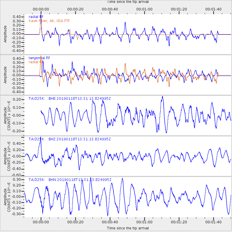
D25K Kavik River, AK, USA - Earthquake Result Viewer
*The percent match for this event was below the threshold and hence no stack was calculated.
| Earthquake location: |
Vanuatu Islands |
| Earthquake latitude/longitude: |
-19.2/168.6 |
| Earthquake time(UTC): |
2019/01/18 (018) 13:18:32 GMT |
| Earthquake Depth: |
45 km |
| Earthquake Magnitude: |
6.0 Mww |
| Earthquake Catalog/Contributor: |
NEIC PDE/us |
|
| Network: |
TA USArray Transportable Network (new EarthScope stations) |
| Station: |
D25K Kavik River, AK, USA |
| Lat/Lon: |
69.32 N/146.38 W |
| Elevation: |
770 m |
|
| Distance: |
93.9 deg |
| Az: |
14.579 deg |
| Baz: |
222.044 deg |
| Ray Param: |
$rayparam |
*The percent match for this event was below the threshold and hence was not used in the summary stack. |
|
| Radial Match: |
64.0238 % |
| Radial Bump: |
300 |
| Transverse Match: |
70.44951 % |
| Transverse Bump: |
360 |
| SOD ConfigId: |
13570011 |
| Insert Time: |
2019-05-02 07:59:40.832 +0000 |
| GWidth: |
2.5 |
| Max Bumps: |
400 |
| Tol: |
0.001 |
|
Signal To Noise
| Channel | StoN | STA | LTA |
| TA:D25K: :BHZ:20190118T13:31:13.824995Z | 3.049754 | 2.463241E-7 | 8.076852E-8 |
| TA:D25K: :BHN:20190118T13:31:13.824995Z | 1.3270621 | 1.2887999E-7 | 9.711677E-8 |
| TA:D25K: :BHE:20190118T13:31:13.824995Z | 1.7231022 | 1.3525765E-7 | 7.849659E-8 |
| Arrivals |
| Ps | |
| PpPs | |
| PsPs/PpSs | |


