You are here: Home > Network List > TA - USArray Transportable Network (new EarthScope stations) Stations List
> Station H16K Elim, AK, USA > Earthquake Result Viewer
H16K Elim, AK, USA - Earthquake Result Viewer
| Earthquake location: |
Vanuatu Islands |
| Earthquake latitude/longitude: |
-19.2/168.6 |
| Earthquake time(UTC): |
2019/01/18 (018) 13:18:32 GMT |
| Earthquake Depth: |
45 km |
| Earthquake Magnitude: |
6.0 Mww |
| Earthquake Catalog/Contributor: |
NEIC PDE/us |
|
| Network: |
TA USArray Transportable Network (new EarthScope stations) |
| Station: |
H16K Elim, AK, USA |
| Lat/Lon: |
64.64 N/162.24 W |
| Elevation: |
216 m |
|
| Distance: |
86.5 deg |
| Az: |
12.124 deg |
| Baz: |
207.441 deg |
| Ray Param: |
0.043907546 |
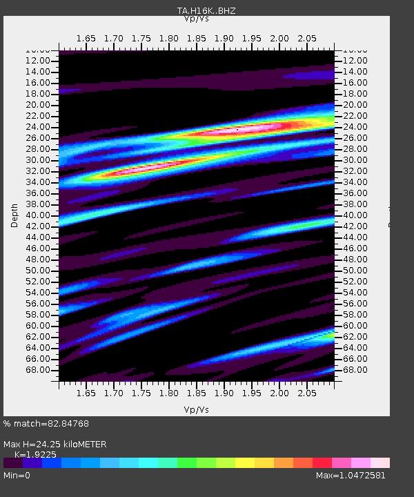
| Estimated Moho Depth: |
24.25 km |
| Estimated Crust Vp/Vs: |
1.92 |
| Assumed Crust Vp: |
6.276 km/s |
| Estimated Crust Vs: |
3.264 km/s |
| Estimated Crust Poisson's Ratio: |
0.31 |
|
| Radial Match: |
82.84768 % |
| Radial Bump: |
400 |
| Transverse Match: |
67.566925 % |
| Transverse Bump: |
400 |
| SOD ConfigId: |
13570011 |
| Insert Time: |
2019-05-02 08:00:03.644 +0000 |
| GWidth: |
2.5 |
| Max Bumps: |
400 |
| Tol: |
0.001 |
|
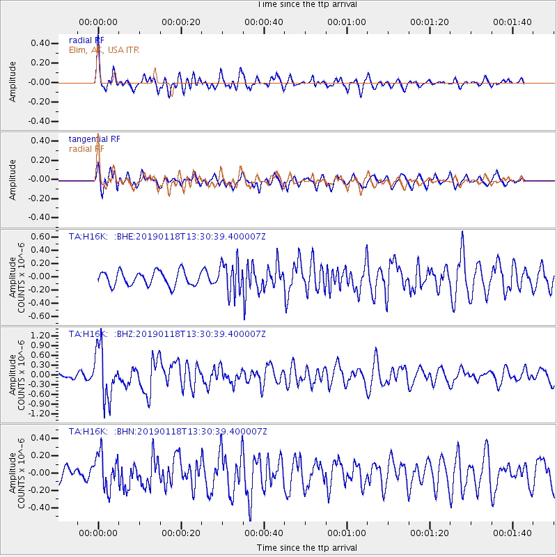
Signal To Noise
| Channel | StoN | STA | LTA |
| TA:H16K: :BHZ:20190118T13:30:39.400007Z | 8.401619 | 7.758435E-7 | 9.234453E-8 |
| TA:H16K: :BHN:20190118T13:30:39.400007Z | 2.0294971 | 2.0499756E-7 | 1.0100904E-7 |
| TA:H16K: :BHE:20190118T13:30:39.400007Z | 2.2132452 | 2.3567027E-7 | 1.0648177E-7 |
| Arrivals |
| Ps | 3.6 SECOND |
| PpPs | 11 SECOND |
| PsPs/PpSs | 15 SECOND |


