You are here: Home > Network List > TA - USArray Transportable Network (new EarthScope stations) Stations List
> Station J26L Joseph Creek, AK, USA > Earthquake Result Viewer
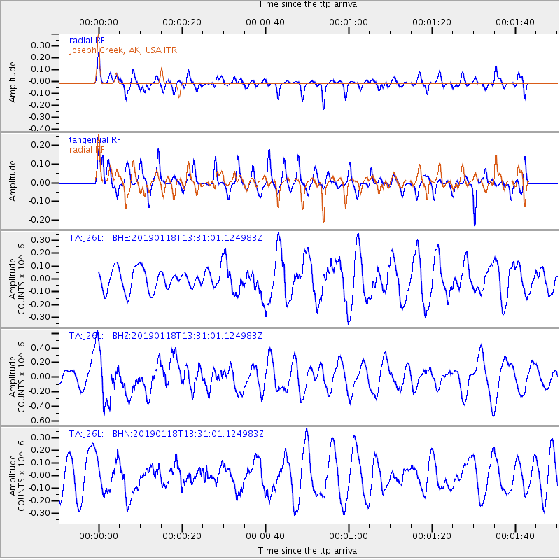
J26L Joseph Creek, AK, USA - Earthquake Result Viewer
*The percent match for this event was below the threshold and hence no stack was calculated.
| Earthquake location: |
Vanuatu Islands |
| Earthquake latitude/longitude: |
-19.2/168.6 |
| Earthquake time(UTC): |
2019/01/18 (018) 13:18:32 GMT |
| Earthquake Depth: |
45 km |
| Earthquake Magnitude: |
6.0 Mww |
| Earthquake Catalog/Contributor: |
NEIC PDE/us |
|
| Network: |
TA USArray Transportable Network (new EarthScope stations) |
| Station: |
J26L Joseph Creek, AK, USA |
| Lat/Lon: |
64.50 N/143.56 W |
| Elevation: |
1144 m |
|
| Distance: |
91.1 deg |
| Az: |
18.708 deg |
| Baz: |
224.447 deg |
| Ray Param: |
$rayparam |
*The percent match for this event was below the threshold and hence was not used in the summary stack. |
|
| Radial Match: |
49.487152 % |
| Radial Bump: |
392 |
| Transverse Match: |
48.054737 % |
| Transverse Bump: |
322 |
| SOD ConfigId: |
13570011 |
| Insert Time: |
2019-05-02 08:00:17.696 +0000 |
| GWidth: |
2.5 |
| Max Bumps: |
400 |
| Tol: |
0.001 |
|
Signal To Noise
| Channel | StoN | STA | LTA |
| TA:J26L: :BHZ:20190118T13:31:01.124983Z | 2.6890028 | 3.4619134E-7 | 1.287434E-7 |
| TA:J26L: :BHN:20190118T13:31:01.124983Z | 0.8983516 | 1.2646609E-7 | 1.4077571E-7 |
| TA:J26L: :BHE:20190118T13:31:01.124983Z | 1.5553056 | 1.24252E-7 | 7.988912E-8 |
| Arrivals |
| Ps | |
| PpPs | |
| PsPs/PpSs | |


