You are here: Home > Network List > TA - USArray Transportable Network (new EarthScope stations) Stations List
> Station C24A Savage, MT, USA > Earthquake Result Viewer
C24A Savage, MT, USA - Earthquake Result Viewer
| Earthquake location: |
Costa Rica |
| Earthquake latitude/longitude: |
10.2/-84.2 |
| Earthquake time(UTC): |
2009/01/08 (008) 19:21:35 GMT |
| Earthquake Depth: |
14 km |
| Earthquake Magnitude: |
5.7 MB, 6.0 MS, 6.1 MW, 6.1 MW |
| Earthquake Catalog/Contributor: |
WHDF/NEIC |
|
| Network: |
TA USArray Transportable Network (new EarthScope stations) |
| Station: |
C24A Savage, MT, USA |
| Lat/Lon: |
47.53 N/104.43 W |
| Elevation: |
713 m |
|
| Distance: |
41.0 deg |
| Az: |
339.065 deg |
| Baz: |
148.729 deg |
| Ray Param: |
0.074067995 |
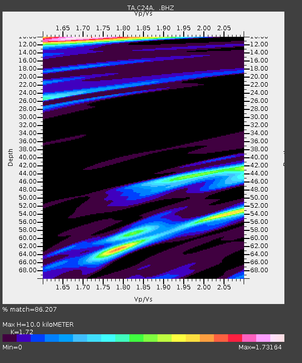
| Estimated Moho Depth: |
10.0 km |
| Estimated Crust Vp/Vs: |
1.72 |
| Assumed Crust Vp: |
6.438 km/s |
| Estimated Crust Vs: |
3.743 km/s |
| Estimated Crust Poisson's Ratio: |
0.24 |
|
| Radial Match: |
86.207 % |
| Radial Bump: |
283 |
| Transverse Match: |
51.58077 % |
| Transverse Bump: |
365 |
| SOD ConfigId: |
2834 |
| Insert Time: |
2010-03-06 19:25:56.246 +0000 |
| GWidth: |
2.5 |
| Max Bumps: |
400 |
| Tol: |
0.001 |
|
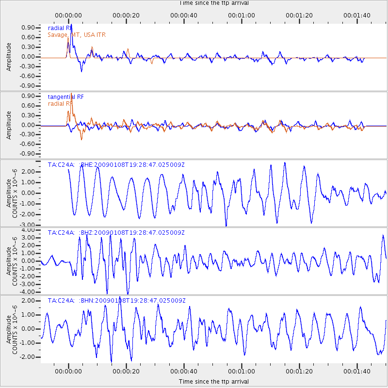
Signal To Noise
| Channel | StoN | STA | LTA |
| TA:C24A: :BHZ:20090108T19:28:47.025009Z | 3.7318568 | 1.3940117E-6 | 3.7354374E-7 |
| TA:C24A: :BHN:20090108T19:28:47.025009Z | 0.5364312 | 6.225568E-7 | 1.160553E-6 |
| TA:C24A: :BHE:20090108T19:28:47.025009Z | 0.9770748 | 1.4174494E-6 | 1.4507071E-6 |
| Arrivals |
| Ps | 1.2 SECOND |
| PpPs | 3.9 SECOND |
| PsPs/PpSs | 5.1 SECOND |


