You are here: Home > Network List > TA - USArray Transportable Network (new EarthScope stations) Stations List
> Station L15K Ungalak Mountain, AK, USA > Earthquake Result Viewer
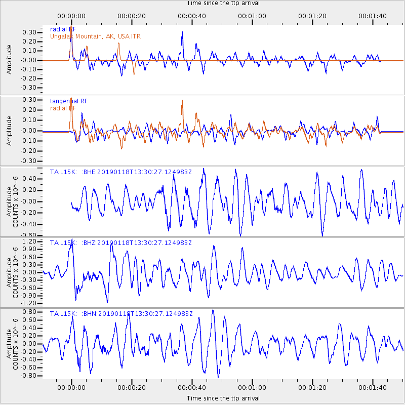
L15K Ungalak Mountain, AK, USA - Earthquake Result Viewer
*The percent match for this event was below the threshold and hence no stack was calculated.
| Earthquake location: |
Vanuatu Islands |
| Earthquake latitude/longitude: |
-19.2/168.6 |
| Earthquake time(UTC): |
2019/01/18 (018) 13:18:32 GMT |
| Earthquake Depth: |
45 km |
| Earthquake Magnitude: |
6.0 Mww |
| Earthquake Catalog/Contributor: |
NEIC PDE/us |
|
| Network: |
TA USArray Transportable Network (new EarthScope stations) |
| Station: |
L15K Ungalak Mountain, AK, USA |
| Lat/Lon: |
61.68 N/161.49 W |
| Elevation: |
219 m |
|
| Distance: |
84.1 deg |
| Az: |
13.819 deg |
| Baz: |
208.251 deg |
| Ray Param: |
$rayparam |
*The percent match for this event was below the threshold and hence was not used in the summary stack. |
|
| Radial Match: |
74.318825 % |
| Radial Bump: |
345 |
| Transverse Match: |
49.47131 % |
| Transverse Bump: |
298 |
| SOD ConfigId: |
13570011 |
| Insert Time: |
2019-05-02 08:00:23.713 +0000 |
| GWidth: |
2.5 |
| Max Bumps: |
400 |
| Tol: |
0.001 |
|
Signal To Noise
| Channel | StoN | STA | LTA |
| TA:L15K: :BHZ:20190118T13:30:27.124983Z | 6.6720448 | 7.1063675E-7 | 1.06509596E-7 |
| TA:L15K: :BHN:20190118T13:30:27.124983Z | 2.487168 | 3.8238107E-7 | 1.5374155E-7 |
| TA:L15K: :BHE:20190118T13:30:27.124983Z | 1.7587242 | 2.8092202E-7 | 1.5973058E-7 |
| Arrivals |
| Ps | |
| PpPs | |
| PsPs/PpSs | |


