You are here: Home > Network List > TA - USArray Transportable Network (new EarthScope stations) Stations List
> Station M16K Timber Creek, AK, USA > Earthquake Result Viewer
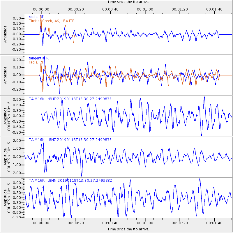
M16K Timber Creek, AK, USA - Earthquake Result Viewer
*The percent match for this event was below the threshold and hence no stack was calculated.
| Earthquake location: |
Vanuatu Islands |
| Earthquake latitude/longitude: |
-19.2/168.6 |
| Earthquake time(UTC): |
2019/01/18 (018) 13:18:32 GMT |
| Earthquake Depth: |
45 km |
| Earthquake Magnitude: |
6.0 Mww |
| Earthquake Catalog/Contributor: |
NEIC PDE/us |
|
| Network: |
TA USArray Transportable Network (new EarthScope stations) |
| Station: |
M16K Timber Creek, AK, USA |
| Lat/Lon: |
61.02 N/158.96 W |
| Elevation: |
394 m |
|
| Distance: |
84.1 deg |
| Az: |
15.211 deg |
| Baz: |
210.609 deg |
| Ray Param: |
$rayparam |
*The percent match for this event was below the threshold and hence was not used in the summary stack. |
|
| Radial Match: |
43.71322 % |
| Radial Bump: |
350 |
| Transverse Match: |
55.63557 % |
| Transverse Bump: |
344 |
| SOD ConfigId: |
13570011 |
| Insert Time: |
2019-05-02 08:00:30.547 +0000 |
| GWidth: |
2.5 |
| Max Bumps: |
400 |
| Tol: |
0.001 |
|
Signal To Noise
| Channel | StoN | STA | LTA |
| TA:M16K: :BHZ:20190118T13:30:27.249983Z | 4.064706 | 1.0630822E-6 | 2.6153975E-7 |
| TA:M16K: :BHN:20190118T13:30:27.249983Z | 1.3006961 | 4.567924E-7 | 3.5119072E-7 |
| TA:M16K: :BHE:20190118T13:30:27.249983Z | 1.0971274 | 3.6462427E-7 | 3.3234448E-7 |
| Arrivals |
| Ps | |
| PpPs | |
| PsPs/PpSs | |


