You are here: Home > Network List > TA - USArray Transportable Network (new EarthScope stations) Stations List
> Station C24A Savage, MT, USA > Earthquake Result Viewer
C24A Savage, MT, USA - Earthquake Result Viewer
| Earthquake location: |
Off Coast Of Ecuador |
| Earthquake latitude/longitude: |
1.4/-85.2 |
| Earthquake time(UTC): |
2009/05/10 (130) 01:16:06 GMT |
| Earthquake Depth: |
6.0 km |
| Earthquake Magnitude: |
5.5 MB, 5.7 MS, 6.1 MW, 6.1 MW |
| Earthquake Catalog/Contributor: |
WHDF/NEIC |
|
| Network: |
TA USArray Transportable Network (new EarthScope stations) |
| Station: |
C24A Savage, MT, USA |
| Lat/Lon: |
47.53 N/104.43 W |
| Elevation: |
713 m |
|
| Distance: |
48.9 deg |
| Az: |
342.749 deg |
| Baz: |
154.056 deg |
| Ray Param: |
0.06906118 |
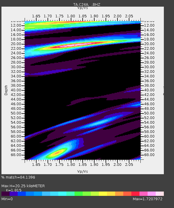
| Estimated Moho Depth: |
20.25 km |
| Estimated Crust Vp/Vs: |
1.82 |
| Assumed Crust Vp: |
6.438 km/s |
| Estimated Crust Vs: |
3.547 km/s |
| Estimated Crust Poisson's Ratio: |
0.28 |
|
| Radial Match: |
84.1396 % |
| Radial Bump: |
289 |
| Transverse Match: |
55.796623 % |
| Transverse Bump: |
400 |
| SOD ConfigId: |
2760 |
| Insert Time: |
2010-03-06 19:25:59.416 +0000 |
| GWidth: |
2.5 |
| Max Bumps: |
400 |
| Tol: |
0.001 |
|

Signal To Noise
| Channel | StoN | STA | LTA |
| TA:C24A: :BHZ:20090510T01:24:22.625009Z | 3.8893 | 5.623995E-7 | 1.4460173E-7 |
| TA:C24A: :BHN:20090510T01:24:22.625009Z | 1.3855613 | 2.4276176E-7 | 1.7520823E-7 |
| TA:C24A: :BHE:20090510T01:24:22.625009Z | 1.092826 | 2.4113356E-7 | 2.2065136E-7 |
| Arrivals |
| Ps | 2.7 SECOND |
| PpPs | 8.4 SECOND |
| PsPs/PpSs | 11 SECOND |


