You are here: Home > Network List > TA - USArray Transportable Network (new EarthScope stations) Stations List
> Station C24A Savage, MT, USA > Earthquake Result Viewer
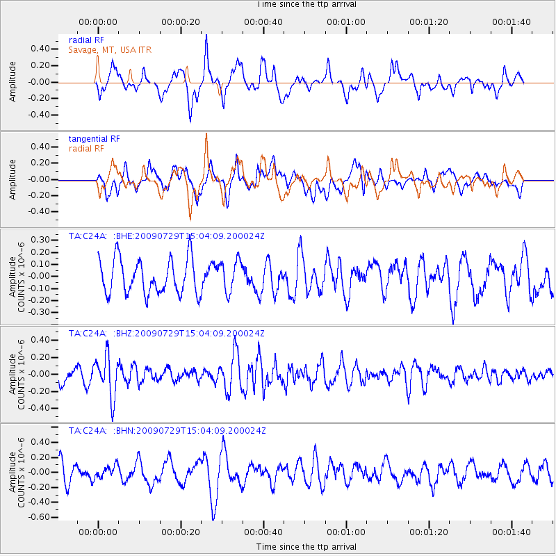
C24A Savage, MT, USA - Earthquake Result Viewer
*The percent match for this event was below the threshold and hence no stack was calculated.
| Earthquake location: |
Volcano Islands, Japan Region |
| Earthquake latitude/longitude: |
22.6/143.3 |
| Earthquake time(UTC): |
2009/07/29 (210) 14:52:08 GMT |
| Earthquake Depth: |
140 km |
| Earthquake Magnitude: |
5.5 MW, 5.2 MB, 5.4 MW |
| Earthquake Catalog/Contributor: |
WHDF/NEIC |
|
| Network: |
TA USArray Transportable Network (new EarthScope stations) |
| Station: |
C24A Savage, MT, USA |
| Lat/Lon: |
47.53 N/104.43 W |
| Elevation: |
713 m |
|
| Distance: |
87.5 deg |
| Az: |
38.866 deg |
| Baz: |
301.142 deg |
| Ray Param: |
$rayparam |
*The percent match for this event was below the threshold and hence was not used in the summary stack. |
|
| Radial Match: |
51.06481 % |
| Radial Bump: |
362 |
| Transverse Match: |
54.478172 % |
| Transverse Bump: |
400 |
| SOD ConfigId: |
2622 |
| Insert Time: |
2010-03-06 19:26:03.996 +0000 |
| GWidth: |
2.5 |
| Max Bumps: |
400 |
| Tol: |
0.001 |
|
Signal To Noise
| Channel | StoN | STA | LTA |
| TA:C24A: :BHZ:20090729T15:04:09.200024Z | 2.2869313 | 2.4956407E-7 | 1.0912618E-7 |
| TA:C24A: :BHN:20090729T15:04:09.200024Z | 0.5780525 | 7.984979E-8 | 1.3813587E-7 |
| TA:C24A: :BHE:20090729T15:04:09.200024Z | 0.90487635 | 1.3175811E-7 | 1.4560898E-7 |
| Arrivals |
| Ps | |
| PpPs | |
| PsPs/PpSs | |


