You are here: Home > Network List > TA - USArray Transportable Network (new EarthScope stations) Stations List
> Station C24A Savage, MT, USA > Earthquake Result Viewer
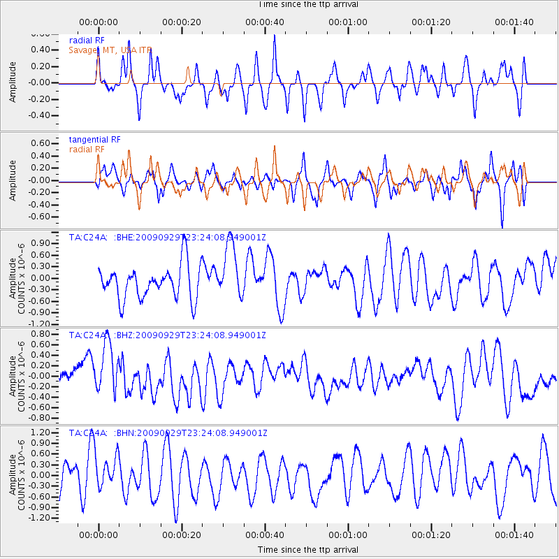
C24A Savage, MT, USA - Earthquake Result Viewer
*The percent match for this event was below the threshold and hence no stack was calculated.
| Earthquake location: |
Tonga Islands |
| Earthquake latitude/longitude: |
-15.6/-173.4 |
| Earthquake time(UTC): |
2009/09/29 (272) 23:11:51 GMT |
| Earthquake Depth: |
10 km |
| Earthquake Magnitude: |
5.5 MB |
| Earthquake Catalog/Contributor: |
WHDF/NEIC |
|
| Network: |
TA USArray Transportable Network (new EarthScope stations) |
| Station: |
C24A Savage, MT, USA |
| Lat/Lon: |
47.53 N/104.43 W |
| Elevation: |
713 m |
|
| Distance: |
87.8 deg |
| Az: |
39.263 deg |
| Baz: |
244.148 deg |
| Ray Param: |
$rayparam |
*The percent match for this event was below the threshold and hence was not used in the summary stack. |
|
| Radial Match: |
65.674164 % |
| Radial Bump: |
366 |
| Transverse Match: |
64.32838 % |
| Transverse Bump: |
390 |
| SOD ConfigId: |
2622 |
| Insert Time: |
2010-03-06 19:26:26.455 +0000 |
| GWidth: |
2.5 |
| Max Bumps: |
400 |
| Tol: |
0.001 |
|
Signal To Noise
| Channel | StoN | STA | LTA |
| TA:C24A: :BHZ:20090929T23:24:08.949001Z | 1.8532134 | 5.438911E-7 | 2.9348539E-7 |
| TA:C24A: :BHN:20090929T23:24:08.949001Z | 1.2702153 | 4.184683E-7 | 3.2944678E-7 |
| TA:C24A: :BHE:20090929T23:24:08.949001Z | 1.7466819 | 7.5690286E-7 | 4.3333753E-7 |
| Arrivals |
| Ps | |
| PpPs | |
| PsPs/PpSs | |


