You are here: Home > Network List > TA - USArray Transportable Network (new EarthScope stations) Stations List
> Station C24A Savage, MT, USA > Earthquake Result Viewer
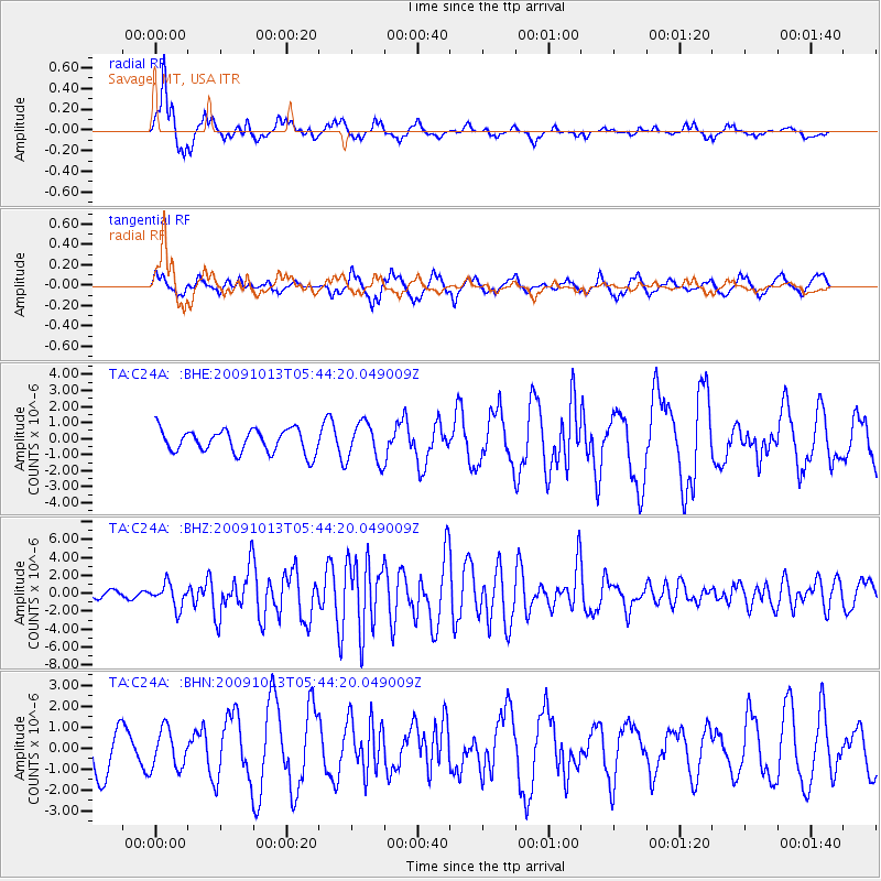
C24A Savage, MT, USA - Earthquake Result Viewer
*The percent match for this event was below the threshold and hence no stack was calculated.
| Earthquake location: |
Fox Islands, Aleutian Islands |
| Earthquake latitude/longitude: |
52.8/-167.0 |
| Earthquake time(UTC): |
2009/10/13 (286) 05:37:23 GMT |
| Earthquake Depth: |
24 km |
| Earthquake Magnitude: |
6.0 MB, 6.1 MS, 6.5 MW, 6.5 MW |
| Earthquake Catalog/Contributor: |
WHDF/NEIC |
|
| Network: |
TA USArray Transportable Network (new EarthScope stations) |
| Station: |
C24A Savage, MT, USA |
| Lat/Lon: |
47.53 N/104.43 W |
| Elevation: |
713 m |
|
| Distance: |
39.3 deg |
| Az: |
71.686 deg |
| Baz: |
301.626 deg |
| Ray Param: |
$rayparam |
*The percent match for this event was below the threshold and hence was not used in the summary stack. |
|
| Radial Match: |
85.90368 % |
| Radial Bump: |
320 |
| Transverse Match: |
65.709724 % |
| Transverse Bump: |
396 |
| SOD ConfigId: |
2622 |
| Insert Time: |
2010-03-06 19:26:29.122 +0000 |
| GWidth: |
2.5 |
| Max Bumps: |
400 |
| Tol: |
0.001 |
|
Signal To Noise
| Channel | StoN | STA | LTA |
| TA:C24A: :BHZ:20091013T05:44:20.049009Z | 3.9326446 | 1.3121322E-6 | 3.3365134E-7 |
| TA:C24A: :BHN:20091013T05:44:20.049009Z | 0.5671741 | 9.2693534E-7 | 1.6343049E-6 |
| TA:C24A: :BHE:20091013T05:44:20.049009Z | 1.7042968 | 1.2230437E-6 | 7.1762366E-7 |
| Arrivals |
| Ps | |
| PpPs | |
| PsPs/PpSs | |


