You are here: Home > Network List > TA - USArray Transportable Network (new EarthScope stations) Stations List
> Station C24A Savage, MT, USA > Earthquake Result Viewer
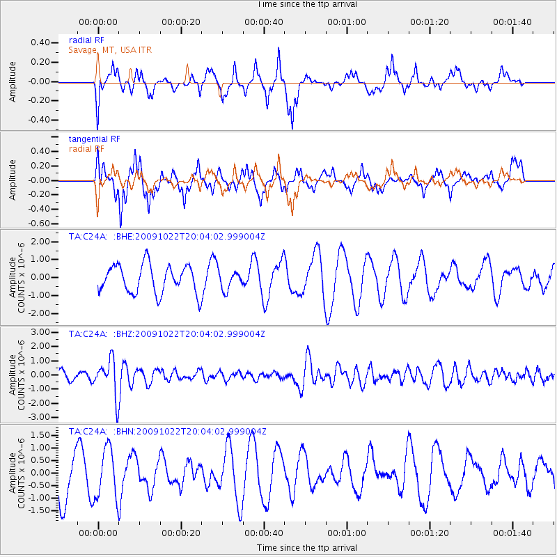
C24A Savage, MT, USA - Earthquake Result Viewer
*The percent match for this event was below the threshold and hence no stack was calculated.
| Earthquake location: |
Hindu Kush Region, Afghanistan |
| Earthquake latitude/longitude: |
36.5/70.9 |
| Earthquake time(UTC): |
2009/10/22 (295) 19:51:27 GMT |
| Earthquake Depth: |
186 km |
| Earthquake Magnitude: |
6.1 MB, 6.2 MW, 6.1 MW |
| Earthquake Catalog/Contributor: |
WHDF/NEIC |
|
| Network: |
TA USArray Transportable Network (new EarthScope stations) |
| Station: |
C24A Savage, MT, USA |
| Lat/Lon: |
47.53 N/104.43 W |
| Elevation: |
713 m |
|
| Distance: |
96.2 deg |
| Az: |
356.849 deg |
| Baz: |
3.746 deg |
| Ray Param: |
$rayparam |
*The percent match for this event was below the threshold and hence was not used in the summary stack. |
|
| Radial Match: |
40.995922 % |
| Radial Bump: |
363 |
| Transverse Match: |
51.590523 % |
| Transverse Bump: |
355 |
| SOD ConfigId: |
2622 |
| Insert Time: |
2010-03-06 19:26:31.742 +0000 |
| GWidth: |
2.5 |
| Max Bumps: |
400 |
| Tol: |
0.001 |
|
Signal To Noise
| Channel | StoN | STA | LTA |
| TA:C24A: :BHZ:20091022T20:04:02.999004Z | 5.094228 | 1.3233804E-6 | 2.5978036E-7 |
| TA:C24A: :BHN:20091022T20:04:02.999004Z | 1.2869017 | 1.0020051E-6 | 7.7861824E-7 |
| TA:C24A: :BHE:20091022T20:04:02.999004Z | 0.63278484 | 4.984292E-7 | 7.876756E-7 |
| Arrivals |
| Ps | |
| PpPs | |
| PsPs/PpSs | |


