You are here: Home > Network List > TA - USArray Transportable Network (new EarthScope stations) Stations List
> Station C24A Savage, MT, USA > Earthquake Result Viewer
C24A Savage, MT, USA - Earthquake Result Viewer
*The percent match for this event was below the threshold and hence no stack was calculated.
| Earthquake location: |
Azores Islands Region |
| Earthquake latitude/longitude: |
36.2/-33.9 |
| Earthquake time(UTC): |
2009/11/04 (308) 18:41:44 GMT |
| Earthquake Depth: |
10 km |
| Earthquake Magnitude: |
5.7 MB, 5.6 MS, 5.9 MW, 5.8 MW |
| Earthquake Catalog/Contributor: |
WHDF/NEIC |
|
| Network: |
TA USArray Transportable Network (new EarthScope stations) |
| Station: |
C24A Savage, MT, USA |
| Lat/Lon: |
47.53 N/104.43 W |
| Elevation: |
713 m |
|
| Distance: |
52.1 deg |
| Az: |
305.903 deg |
| Baz: |
75.323 deg |
| Ray Param: |
$rayparam |
*The percent match for this event was below the threshold and hence was not used in the summary stack. |
|
| Radial Match: |
79.95475 % |
| Radial Bump: |
344 |
| Transverse Match: |
56.825245 % |
| Transverse Bump: |
261 |
| SOD ConfigId: |
2622 |
| Insert Time: |
2010-03-06 19:26:36.045 +0000 |
| GWidth: |
2.5 |
| Max Bumps: |
400 |
| Tol: |
0.001 |
|
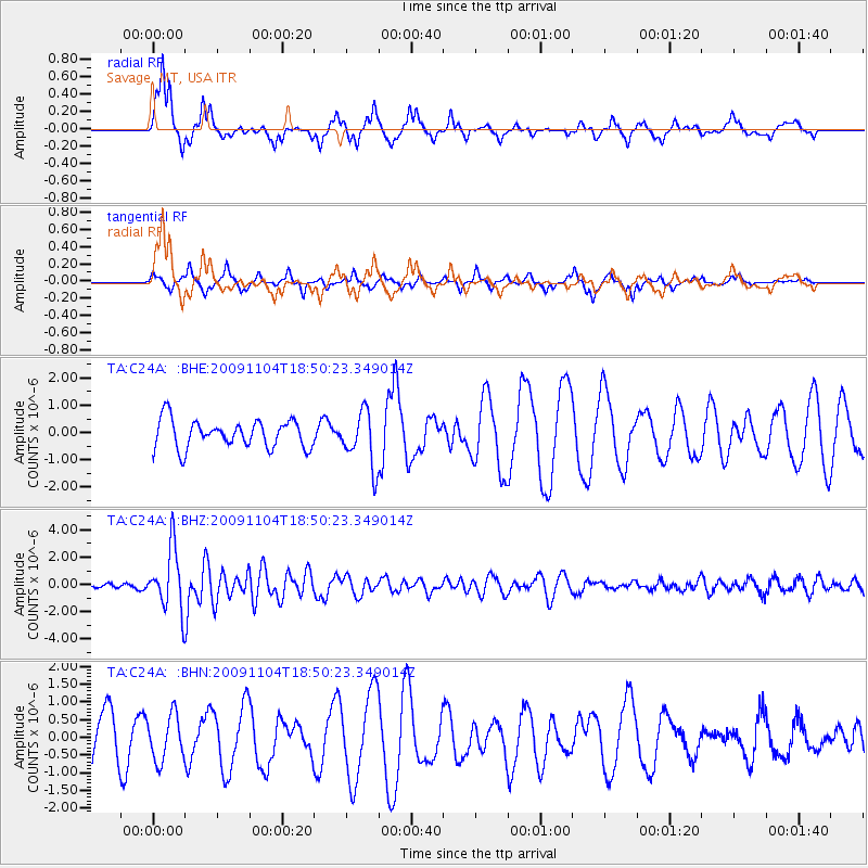
Signal To Noise
| Channel | StoN | STA | LTA |
| TA:C24A: :BHZ:20091104T18:50:23.349014Z | 5.7104087 | 2.2423235E-6 | 3.92673E-7 |
| TA:C24A: :BHN:20091104T18:50:23.349014Z | 0.9175128 | 6.355318E-7 | 6.926681E-7 |
| TA:C24A: :BHE:20091104T18:50:23.349014Z | 1.9216686 | 9.887117E-7 | 5.1450684E-7 |
| Arrivals |
| Ps | |
| PpPs | |
| PsPs/PpSs | |


