You are here: Home > Network List > TA - USArray Transportable Network (new EarthScope stations) Stations List
> Station C24A Savage, MT, USA > Earthquake Result Viewer
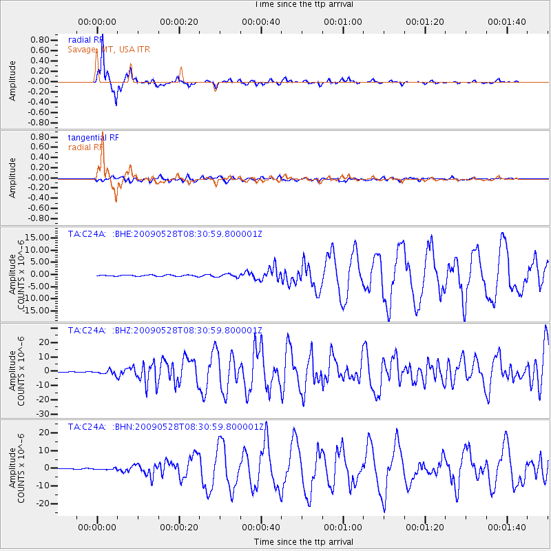
C24A Savage, MT, USA - Earthquake Result Viewer
*The percent match for this event was below the threshold and hence no stack was calculated.
| Earthquake location: |
North Of Honduras |
| Earthquake latitude/longitude: |
16.7/-86.2 |
| Earthquake time(UTC): |
2009/05/28 (148) 08:24:45 GMT |
| Earthquake Depth: |
10 km |
| Earthquake Magnitude: |
6.7 MB, 7.2 MS, 7.3 MW, 7.3 MW |
| Earthquake Catalog/Contributor: |
WHDF/NEIC |
|
| Network: |
TA USArray Transportable Network (new EarthScope stations) |
| Station: |
C24A Savage, MT, USA |
| Lat/Lon: |
47.53 N/104.43 W |
| Elevation: |
713 m |
|
| Distance: |
34.2 deg |
| Az: |
337.883 deg |
| Baz: |
147.833 deg |
| Ray Param: |
$rayparam |
*The percent match for this event was below the threshold and hence was not used in the summary stack. |
|
| Radial Match: |
98.18849 % |
| Radial Bump: |
217 |
| Transverse Match: |
83.822136 % |
| Transverse Bump: |
400 |
| SOD ConfigId: |
2648 |
| Insert Time: |
2010-03-06 19:26:36.850 +0000 |
| GWidth: |
2.5 |
| Max Bumps: |
400 |
| Tol: |
0.001 |
|
Signal To Noise
| Channel | StoN | STA | LTA |
| TA:C24A: :BHZ:20090528T08:30:59.800001Z | 9.65975 | 1.5500906E-6 | 1.6046901E-7 |
| TA:C24A: :BHN:20090528T08:30:59.800001Z | 1.7815473 | 3.4276692E-7 | 1.9239843E-7 |
| TA:C24A: :BHE:20090528T08:30:59.800001Z | 2.3459983 | 6.340833E-7 | 2.702829E-7 |
| Arrivals |
| Ps | |
| PpPs | |
| PsPs/PpSs | |


