You are here: Home > Network List > TA - USArray Transportable Network (new EarthScope stations) Stations List
> Station C24A Savage, MT, USA > Earthquake Result Viewer
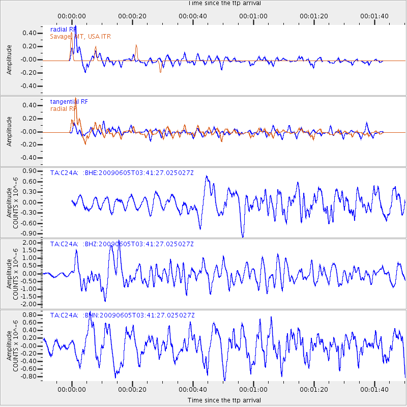
C24A Savage, MT, USA - Earthquake Result Viewer
*The percent match for this event was below the threshold and hence no stack was calculated.
| Earthquake location: |
Hokkaido, Japan Region |
| Earthquake latitude/longitude: |
41.8/143.4 |
| Earthquake time(UTC): |
2009/06/05 (156) 03:30:33 GMT |
| Earthquake Depth: |
29 km |
| Earthquake Magnitude: |
6.0 MB, 6.3 MS, 6.4 MW, 6.4 MW |
| Earthquake Catalog/Contributor: |
WHDF/NEIC |
|
| Network: |
TA USArray Transportable Network (new EarthScope stations) |
| Station: |
C24A Savage, MT, USA |
| Lat/Lon: |
47.53 N/104.43 W |
| Elevation: |
713 m |
|
| Distance: |
72.7 deg |
| Az: |
41.115 deg |
| Baz: |
313.51 deg |
| Ray Param: |
$rayparam |
*The percent match for this event was below the threshold and hence was not used in the summary stack. |
|
| Radial Match: |
88.13699 % |
| Radial Bump: |
330 |
| Transverse Match: |
63.090847 % |
| Transverse Bump: |
400 |
| SOD ConfigId: |
2648 |
| Insert Time: |
2010-03-06 19:26:40.603 +0000 |
| GWidth: |
2.5 |
| Max Bumps: |
400 |
| Tol: |
0.001 |
|
Signal To Noise
| Channel | StoN | STA | LTA |
| TA:C24A: :BHZ:20090605T03:41:27.025027Z | 9.778471 | 7.210204E-7 | 7.373549E-8 |
| TA:C24A: :BHN:20090605T03:41:27.025027Z | 1.654383 | 2.5381942E-7 | 1.5342242E-7 |
| TA:C24A: :BHE:20090605T03:41:27.025027Z | 1.0036327 | 1.3897521E-7 | 1.3847219E-7 |
| Arrivals |
| Ps | |
| PpPs | |
| PsPs/PpSs | |


