You are here: Home > Network List > N4 - Central and EAstern US Network Stations List
> Station P46A Rosedale, IN, USA > Earthquake Result Viewer
P46A Rosedale, IN, USA - Earthquake Result Viewer
| Earthquake location: |
Northern East Pacific Rise |
| Earthquake latitude/longitude: |
8.3/-103.5 |
| Earthquake time(UTC): |
2019/01/18 (018) 16:40:42 GMT |
| Earthquake Depth: |
10 km |
| Earthquake Magnitude: |
6.0 Mww |
| Earthquake Catalog/Contributor: |
NEIC PDE/us |
|
| Network: |
N4 Central and EAstern US Network |
| Station: |
P46A Rosedale, IN, USA |
| Lat/Lon: |
39.62 N/87.21 W |
| Elevation: |
194 m |
|
| Distance: |
34.4 deg |
| Az: |
22.479 deg |
| Baz: |
209.336 deg |
| Ray Param: |
0.07773784 |
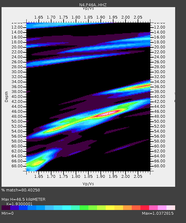
| Estimated Moho Depth: |
46.5 km |
| Estimated Crust Vp/Vs: |
1.93 |
| Assumed Crust Vp: |
6.444 km/s |
| Estimated Crust Vs: |
3.339 km/s |
| Estimated Crust Poisson's Ratio: |
0.32 |
|
| Radial Match: |
80.40258 % |
| Radial Bump: |
400 |
| Transverse Match: |
45.400543 % |
| Transverse Bump: |
301 |
| SOD ConfigId: |
13570011 |
| Insert Time: |
2019-05-02 08:06:45.462 +0000 |
| GWidth: |
2.5 |
| Max Bumps: |
400 |
| Tol: |
0.001 |
|

Signal To Noise
| Channel | StoN | STA | LTA |
| N4:P46A: :HHZ:20190118T16:46:58.520011Z | 3.0306177 | 1.204896E-6 | 3.9757438E-7 |
| N4:P46A: :HHN:20190118T16:46:58.520011Z | 2.025014 | 5.329598E-7 | 2.6318824E-7 |
| N4:P46A: :HHE:20190118T16:46:58.520011Z | 1.7551237 | 4.830759E-7 | 2.752375E-7 |
| Arrivals |
| Ps | 7.2 SECOND |
| PpPs | 20 SECOND |
| PsPs/PpSs | 27 SECOND |


