You are here: Home > Network List > TA - USArray Transportable Network (new EarthScope stations) Stations List
> Station C24A Savage, MT, USA > Earthquake Result Viewer
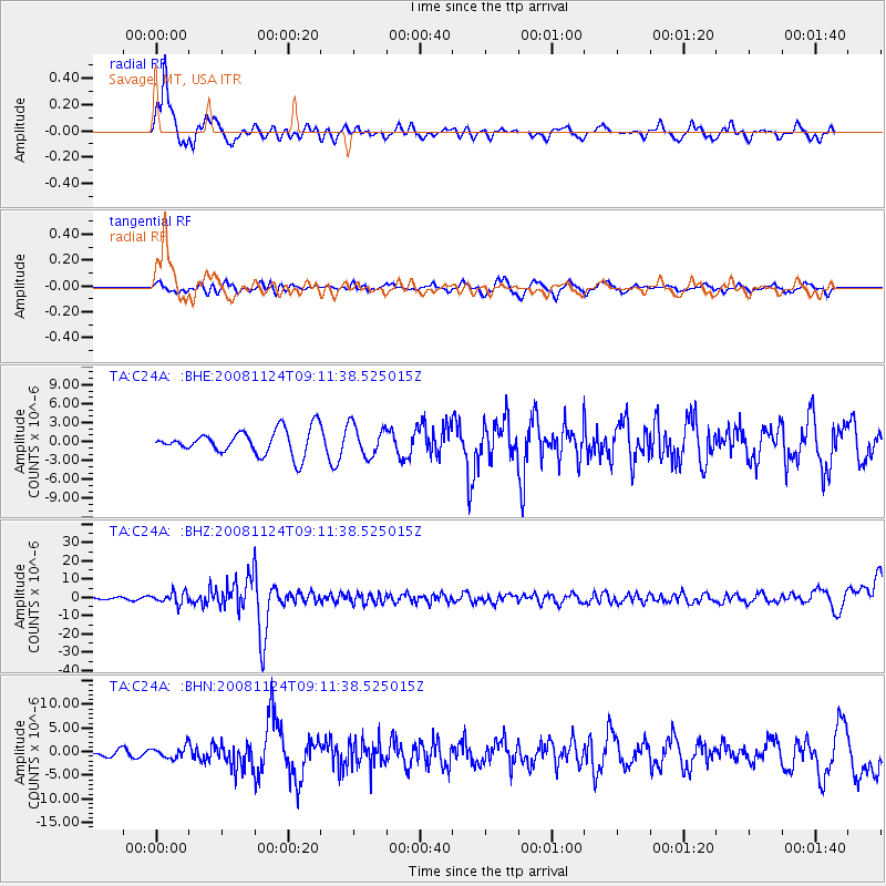
C24A Savage, MT, USA - Earthquake Result Viewer
*The percent match for this event was below the threshold and hence no stack was calculated.
| Earthquake location: |
Sea Of Okhotsk |
| Earthquake latitude/longitude: |
54.2/154.3 |
| Earthquake time(UTC): |
2008/11/24 (329) 09:02:58 GMT |
| Earthquake Depth: |
492 km |
| Earthquake Magnitude: |
6.5 MB, 7.3 MW, 7.3 MW |
| Earthquake Catalog/Contributor: |
WHDF/NEIC |
|
| Network: |
TA USArray Transportable Network (new EarthScope stations) |
| Station: |
C24A Savage, MT, USA |
| Lat/Lon: |
47.53 N/104.43 W |
| Elevation: |
713 m |
|
| Distance: |
58.8 deg |
| Az: |
50.957 deg |
| Baz: |
317.675 deg |
| Ray Param: |
$rayparam |
*The percent match for this event was below the threshold and hence was not used in the summary stack. |
|
| Radial Match: |
78.91067 % |
| Radial Bump: |
400 |
| Transverse Match: |
34.908253 % |
| Transverse Bump: |
400 |
| SOD ConfigId: |
2658 |
| Insert Time: |
2010-03-06 19:26:41.637 +0000 |
| GWidth: |
2.5 |
| Max Bumps: |
400 |
| Tol: |
0.001 |
|
Signal To Noise
| Channel | StoN | STA | LTA |
| TA:C24A: :BHZ:20081124T09:11:38.525015Z | 3.9127197 | 3.1212533E-6 | 7.977196E-7 |
| TA:C24A: :BHN:20081124T09:11:38.525015Z | 0.58740383 | 1.2105303E-6 | 2.0608143E-6 |
| TA:C24A: :BHE:20081124T09:11:38.525015Z | 1.2655822 | 2.4580183E-6 | 1.9422037E-6 |
| Arrivals |
| Ps | |
| PpPs | |
| PsPs/PpSs | |


